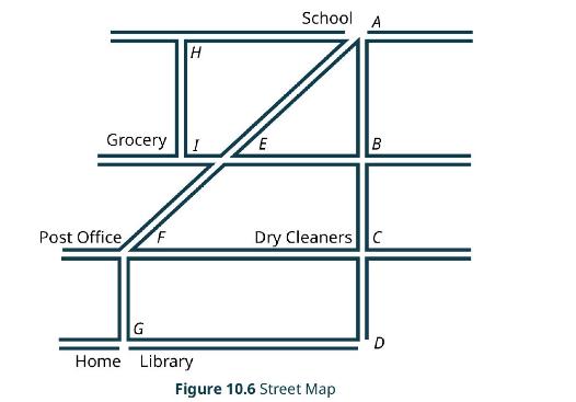
View the street map (Figure 10.6) as a series of line segments from point to point. For
Question:
View the street map (Figure 10.6) as a series of line segments from point to point. For example, we have vertical line segments \(\overline{A B}, \overline{B C}\), and \(\overline{C D}\) on the right. On the left side of the map, we have vertical line segments \(\overline{H I}, \overline{F G}\). The horizontal line segments are \(\overline{H A}, \overline{E I}, \overline{I E}, \overline{E B}, \overline{F C}, \overline{C F}\), and \(\overline{G B}\). There are two diagonal line segments, \(\overline{A E}\) and \(\overline{E F}\). Assume that each location is on a corner and that you live next door to the library.
 1. Let's say that you want to stop at the grocery store on your way home from school. Come up with three routes you might take to do your errand and then go home. In other words, name the three ways by the line segments in the order you would walk, and which way do you think would be the most efficient route?
2. How about stopping at the library after school? Name four ways you might travel to the library and which way do you think is the most efficient?
3. Suppose you need to go to the post office and the dry cleaners on your way home from school. Name three ways you might walk to do your errands and end up at home. Which way do you think is the most efficient way to walk, get your errands done, and go home?
Step by Step Answer:


