

Question: 1. The following topographic map (Map 3.1) is from a coastal area and features an interesting geological hazard in addition to the Ocean. Using a
1. The following topographic map (Map 3.1) is from a coastal area and features an interesting geological hazard in addition to the Ocean. Using a contour interval of 4o meters, label the elevation of every contour line on the map below. (Note: elevation is meters above sea level, which makes sea level = m). 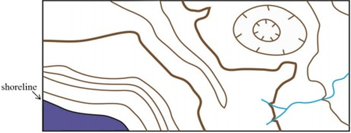
2. Imagine you are a geologist for the United States Geological Survey. You are tasked with creating your own coastal Topographic map, so you hike around the area with a GPS receiver (Global Positioning System) and every so often you record your position along with the elevation in meters at that point, which results in the following map (Map 3.2). Complete Map 3.2 by adding in the contour lines using a contour interval of WO meters. Draw the contour lines so that they are continuous (do not die off), and either continue off the map or form an enclosed circle (look at the topographic map in the problem 1 for an example). More often than not, your contour lines will fall between the GPS points on your map, so do your best to determine the contour line positions. 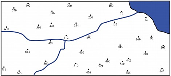
For questions 3-7 refer to the Map 3.3. The following topographic map shows an interesting and informative geological feature called a drumlin, which is a pile of sediment left behind by a retreating glacier. 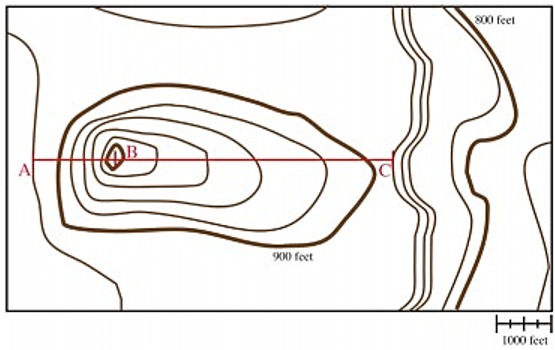
TOPOGRAPHIC MAPS
INTRODUCTORY GEOLOGY
3. What is the contour interval on Map 33?
4. What is the regional relief on Map 3.3?
shoreline 630 570 492 614 506 386 560 441 498 412 334 510 400 250 476 389 1ia 132 306 530 386 .2 210 107 328 B 900 feet 800 feet H+++ 1000 feet
Step by Step Solution
3.47 Rating (157 Votes )
There are 3 Steps involved in it
To address the questions based on the maps provided lets proceed step by step Question 1 Label the e... View full answer

Get step-by-step solutions from verified subject matter experts