Answered step by step
Verified Expert Solution
Question
1 Approved Answer
1. (20 pts) Figure 1 displays a map of highway links between several major cities in Texas Numbers on the edges in Figure 1 show
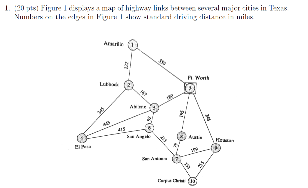
1. (20 pts) Figure 1 displays a map of highway links between several major cities in Texas Numbers on the edges in Figure 1 show standard driving distance in miles. Amarillo (1 Ft. Worth Lubbock 2 Abilene5 415 San Angelo 8 Austin Houston El Paso 9 199 San Antonio 7 Corpus Christi (10 1. (20 pts) Figure 1 displays a map of highway links between several major cities in Texas Numbers on the edges in Figure 1 show standard driving distance in miles. Amarillo (1 Ft. Worth Lubbock 2 Abilene5 415 San Angelo 8 Austin Houston El Paso 9 199 San Antonio 7 Corpus Christi (10
Step by Step Solution
There are 3 Steps involved in it
Step: 1
Get Instant Access to Expert-Tailored Solutions
See step-by-step solutions with expert insights and AI powered tools for academic success
Step: 2
Step: 3
Ace Your Homework with AI
Get the answers you need in no time with our AI-driven, step-by-step assistance
Get Started