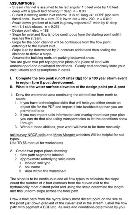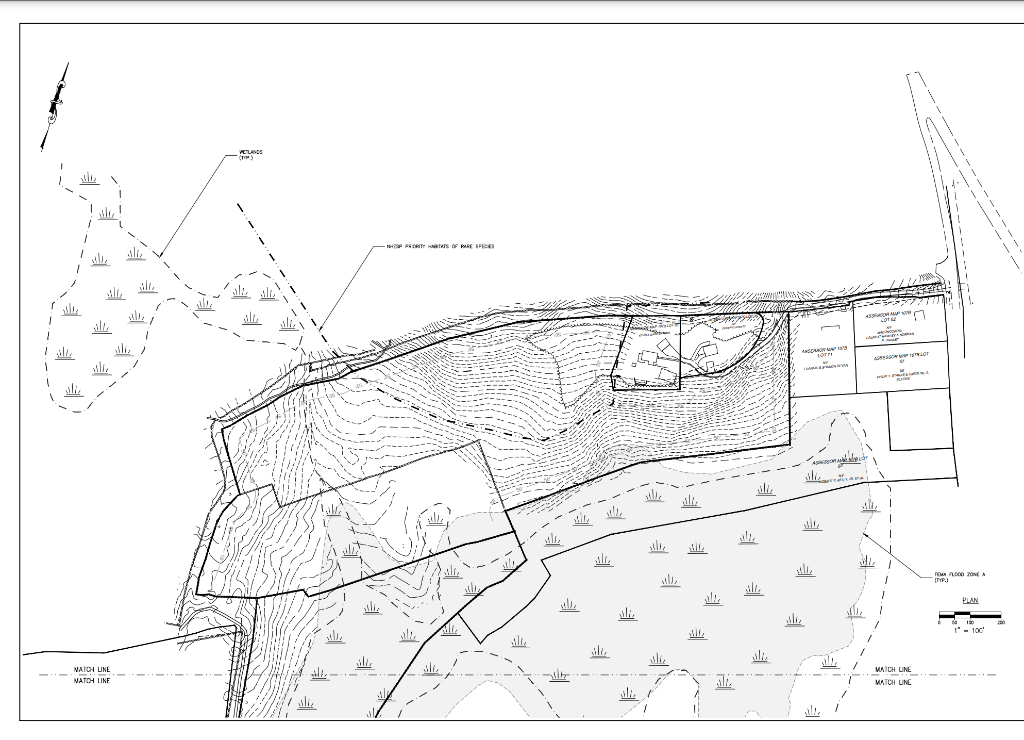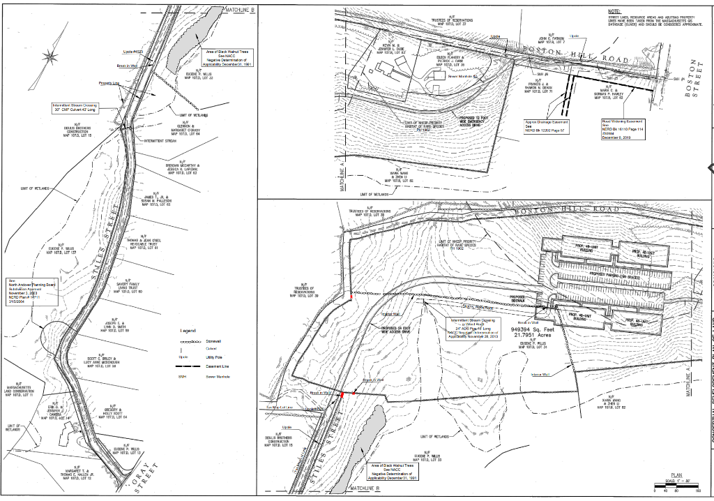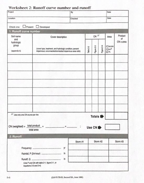


ASSUMPTIONS: Stream channel is assumed to be rectangular 1.5 feet wide by 1.0 feet deep with a gravel bed flowing 3" deep. n = 0.03 Culvert is flowing under inlet control . it is 16' long 24" HDPE pipe with flared ends. Invert in = elev. 201; invert out = elev. 200. n=0.012 Swale down gradient of culvert is grassy trapezoid 2' wide by 6 deep with 1:1 side slopes. n = 0.035 Design point elev. = 188 Slope for overland flow is to be continuous from the starting point until it reaches the stream Slope for the open channel will be continuous from the flow point entering it to the culvert inlet. Slope is to be determined by 2' contours added and then scaling the distance to derive a slope. Assume the building roofs are parking lot/paved areas. You are given two pdf topographic plans of a piece of land with undeveloped and developed conditions. Clearly and concisely state your calculations and assumptions in detail. I. Compute the two peak runoff rates Q(p) for a 100 year storm event in region 1pre & post development. II. What is the water surface elevation at the design point pre & post 1. Draw the watershed area continuing the dotted line from north to south. 1. If you have technological skills that will help you either create an object file for the PDF and import it into landdesktop then you are permitted to so 2. if you can import soils information and overlay them over your plan you can do that also using transparencies to let the conditions show through 3. Without those abilities, your work will have to be done manually. soil survey NRCS soils and Mass Mapper websites will be helpful for soil types. Use TR 55 manual for worksheets 2. Create two paper plans showing: 1. flow path segments labeled 2. approximate underlying soils areas 1. labeled soil type 2. soil name 3. Area within the watershed The slope is to be continuous and all flow types to calculate the slope count the number of 2 foot contours from the culvert exit to the hydraulically most distant point and using the scale determine the length and this uniform slope across the floor path. Draw a flow path from the hydraulically most distant point on the site to the point just down gradient of the culvert exit in the stream. Label the flow path with segment a BCD etc. As soils and conditions determined by you VERLANDS (T) 1 NESP PSCRITT WARTATS OF RESPECES w UP 1 AEON MAP OR OU SO ulla al ali will all, 16 ale al JI ul POR LO ZONA ITP.) PLAN ali . . 130 1 - 100' ali WATCH LINE NATO UNE WATCH LINE WATCH LINE MATCHLINE B TUSTEES OPERATING MP100033 NOTE: ETUS RESOURCE WOH MAWO MONT LES WIE BESTAO PONTE MASSAOUETTS INTISIZ OUNCED SHOULD BE COMPROMATE + JON MPOR 17 MENN WORLD RLO U23 free laskut SNAG Versand Aployee BOSTON HILL ROAD 23 GLEDI RRERY PROX MAP HALF Rain will BUDDIE www Trap M NUT SHEN BIT.LOT 1 STREET M MSR HALEY Pure Herm 0 CMP Cuvet Lang II por for DE DOING COSSON MY BIR GONS MAP 100.. LOT 13 4 UMT OF KLE NAF CLERON MOST CRY wator TENT STREAM TUTOR Me Web NERDO 1610 Page 114 MENU 128 December 2013 POUR ESCALE tru NU MNP LOG LIHT OF KURES IMT OF . SUM FLES MAP 10., TRES PT. LOT BOSTOSSSTELLROAD NA el NEVOCABLE TRUST TEL, LOT! UNIT OPPORTY TRT OF ROS MIL| ITDLOT 139 BILEN . North Andorrning Gear November 3, 2045 NERD 15 SAMORTALY UNT A LOT 50 NT Trust RS MO BAN MH 1. LOT IROR - For WOE 1028 . 24 At Long TO A 2013 wa 949394 Sq. Foet 21.7951 Acres HT BUS. WP SLOT 1 NA Soon & BLY LEY AAN MCDONG ELS LI Seele BH w .. HAT MAN LAND MAP TO theatre wa TU TELOT EMPER CS MP LOT 14 GRESORY HOLLYS NAPITAL 64 NAF WHERS PHITE LOT 15 F NUS PHITD. LOT 13 REMUS APMET, LOT 33 Ars of TV NCC Mers aplicable December MET LA TONS C MALLIEN MA 17 LOT GRAY STREET PLAN . KATCHUNEB Worksheet 2: Runoff curve number and runoff Project By Date Location Checked Dw Check one present Developed 1. Runoff curve number Cover description CN Area Soil name and hydrologic group Product of CN area over type, treatment, and hydrologie control impervious connected connected intervious are ratio) (appendix Foue 24 T22 acres D ON by Use only one CN source perine Totals Use CN CN (weighted a total product total area 2. Runott Storm #1 Storm #2 Storm 3 y in Frequency Rainfall P (24-hour Runott, (Us P and CN with luble 2-1,Tigure 21,0 quations 23 and 2-4) in (210-VL-TB-36, Second 24, June 1986) ASSUMPTIONS: Stream channel is assumed to be rectangular 1.5 feet wide by 1.0 feet deep with a gravel bed flowing 3" deep. n = 0.03 Culvert is flowing under inlet control . it is 16' long 24" HDPE pipe with flared ends. Invert in = elev. 201; invert out = elev. 200. n=0.012 Swale down gradient of culvert is grassy trapezoid 2' wide by 6 deep with 1:1 side slopes. n = 0.035 Design point elev. = 188 Slope for overland flow is to be continuous from the starting point until it reaches the stream Slope for the open channel will be continuous from the flow point entering it to the culvert inlet. Slope is to be determined by 2' contours added and then scaling the distance to derive a slope. Assume the building roofs are parking lot/paved areas. You are given two pdf topographic plans of a piece of land with undeveloped and developed conditions. Clearly and concisely state your calculations and assumptions in detail. I. Compute the two peak runoff rates Q(p) for a 100 year storm event in region 1pre & post development. II. What is the water surface elevation at the design point pre & post 1. Draw the watershed area continuing the dotted line from north to south. 1. If you have technological skills that will help you either create an object file for the PDF and import it into landdesktop then you are permitted to so 2. if you can import soils information and overlay them over your plan you can do that also using transparencies to let the conditions show through 3. Without those abilities, your work will have to be done manually. soil survey NRCS soils and Mass Mapper websites will be helpful for soil types. Use TR 55 manual for worksheets 2. Create two paper plans showing: 1. flow path segments labeled 2. approximate underlying soils areas 1. labeled soil type 2. soil name 3. Area within the watershed The slope is to be continuous and all flow types to calculate the slope count the number of 2 foot contours from the culvert exit to the hydraulically most distant point and using the scale determine the length and this uniform slope across the floor path. Draw a flow path from the hydraulically most distant point on the site to the point just down gradient of the culvert exit in the stream. Label the flow path with segment a BCD etc. As soils and conditions determined by you VERLANDS (T) 1 NESP PSCRITT WARTATS OF RESPECES w UP 1 AEON MAP OR OU SO ulla al ali will all, 16 ale al JI ul POR LO ZONA ITP.) PLAN ali . . 130 1 - 100' ali WATCH LINE NATO UNE WATCH LINE WATCH LINE MATCHLINE B TUSTEES OPERATING MP100033 NOTE: ETUS RESOURCE WOH MAWO MONT LES WIE BESTAO PONTE MASSAOUETTS INTISIZ OUNCED SHOULD BE COMPROMATE + JON MPOR 17 MENN WORLD RLO U23 free laskut SNAG Versand Aployee BOSTON HILL ROAD 23 GLEDI RRERY PROX MAP HALF Rain will BUDDIE www Trap M NUT SHEN BIT.LOT 1 STREET M MSR HALEY Pure Herm 0 CMP Cuvet Lang II por for DE DOING COSSON MY BIR GONS MAP 100.. LOT 13 4 UMT OF KLE NAF CLERON MOST CRY wator TENT STREAM TUTOR Me Web NERDO 1610 Page 114 MENU 128 December 2013 POUR ESCALE tru NU MNP LOG LIHT OF KURES IMT OF . SUM FLES MAP 10., TRES PT. LOT BOSTOSSSTELLROAD NA el NEVOCABLE TRUST TEL, LOT! UNIT OPPORTY TRT OF ROS MIL| ITDLOT 139 BILEN . North Andorrning Gear November 3, 2045 NERD 15 SAMORTALY UNT A LOT 50 NT Trust RS MO BAN MH 1. LOT IROR - For WOE 1028 . 24 At Long TO A 2013 wa 949394 Sq. Foet 21.7951 Acres HT BUS. WP SLOT 1 NA Soon & BLY LEY AAN MCDONG ELS LI Seele BH w .. HAT MAN LAND MAP TO theatre wa TU TELOT EMPER CS MP LOT 14 GRESORY HOLLYS NAPITAL 64 NAF WHERS PHITE LOT 15 F NUS PHITD. LOT 13 REMUS APMET, LOT 33 Ars of TV NCC Mers aplicable December MET LA TONS C MALLIEN MA 17 LOT GRAY STREET PLAN . KATCHUNEB Worksheet 2: Runoff curve number and runoff Project By Date Location Checked Dw Check one present Developed 1. Runoff curve number Cover description CN Area Soil name and hydrologic group Product of CN area over type, treatment, and hydrologie control impervious connected connected intervious are ratio) (appendix Foue 24 T22 acres D ON by Use only one CN source perine Totals Use CN CN (weighted a total product total area 2. Runott Storm #1 Storm #2 Storm 3 y in Frequency Rainfall P (24-hour Runott, (Us P and CN with luble 2-1,Tigure 21,0 quations 23 and 2-4) in (210-VL-TB-36, Second 24, June 1986)


