Done in python 3.10
First note that you are not allowed to change the names, parameters, etc of functions you are implementing, or even ones you are not implementing. You are also not allowed to change names of any .py files included with the assignment. You are allowed, if you want, to implement additional helper functions if you find it useful. The naming convention for helper functions is to start name with an _ to let other programmers know that you intend it to be private. You will probably need additional import statements, such as the math module. So just add those at the top.
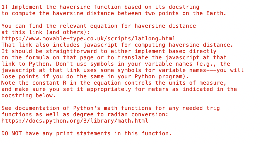
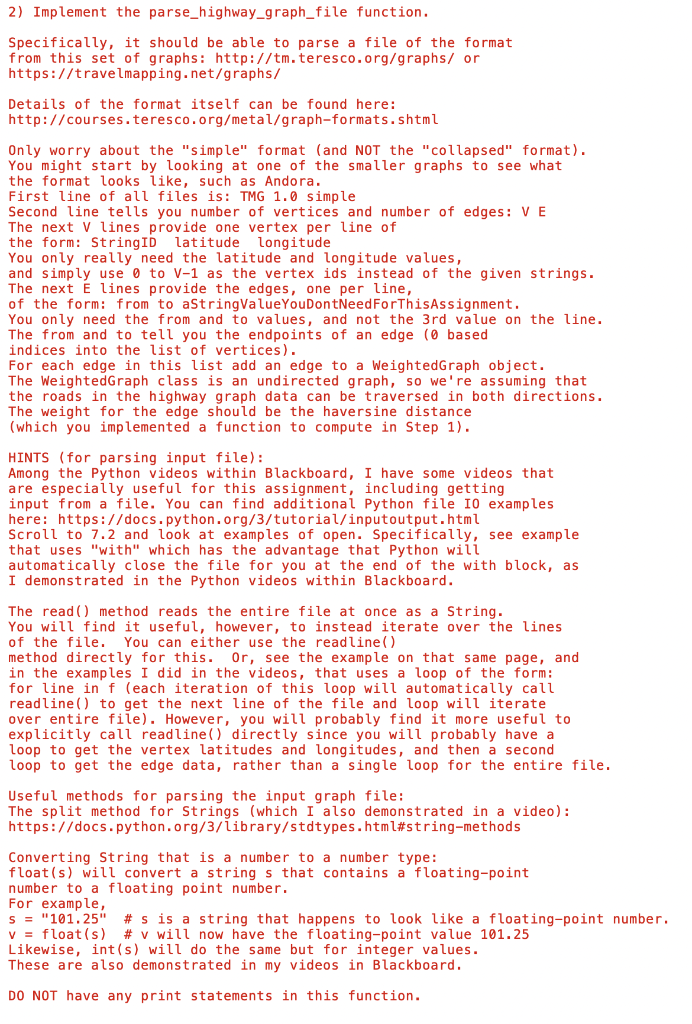
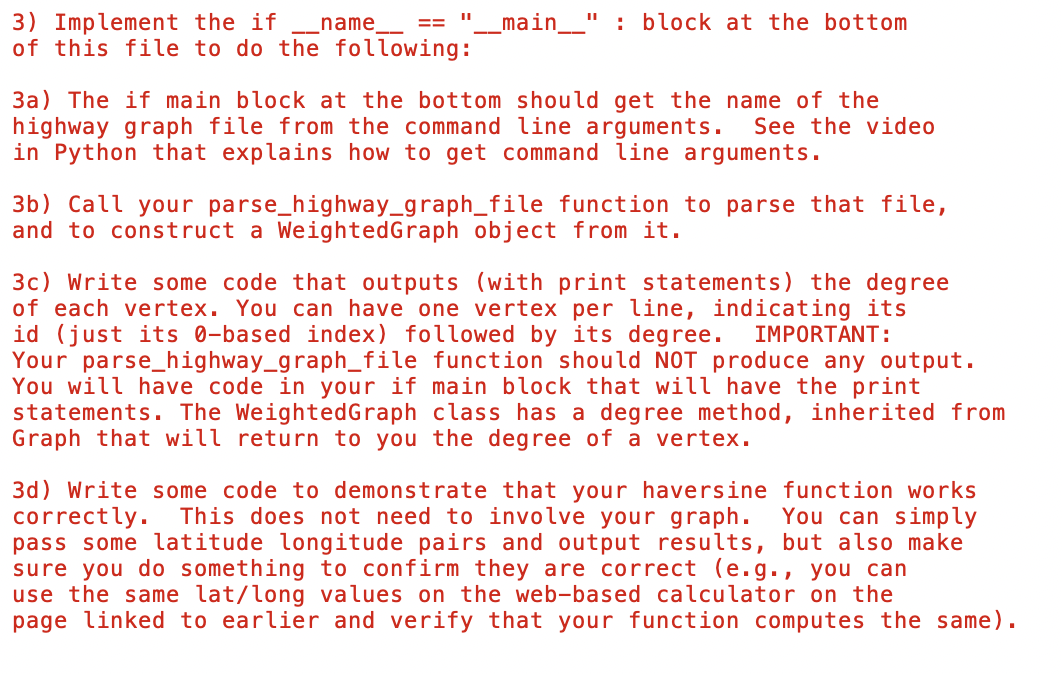
1) Implement the haversine function based on its docstring to compute the haversine distance between two points on the Earth. You can find the relevant equation for haversine distance at this link (and others): https://www.movable-type. co.uk/scripts/latlong.html That link also includes javascript for computing haversine distance. It should be straightforward to either implement based directly on the formula on that page or to translate the javascript at that link to Python. Don't use symbols in your variable names (e.g., the javascript at that link uses some symbols for variable names---you will lose points if you do the same in your Python program). Note the constant R in the equation controls the units of measure, and make sure you set it appropriately for meters as indicated in the docstring below. See documentation of Python's math functions for any needed trig functions as well as degree to radian conversion: https://docs.python. org/3/library/math.html Do NoT have any print statements in this function. 2) Implement the parse_highway_graph_file function. Specifically, it should be able to parse a file of the format from this set of graphs: http://tm.teresco.org/graphs/ or https://travelmapping. net/graphs/ Details of the format itself can be found here: http: // courses.teresco.org/metal/graph-formats. shtml Only worry about the "simple" format (and NOT the "collapsed" format). You might start by looking at one of the smaller graphs to see what the format looks like, such as Andora. First line of all files is: TMG 1.0 simple Second line tells you number of vertices and number of edges: V E The next V lines provide one vertex per line of the form: StringID latitude longitude You only really need the latitude and longitude values, and simply use 0 to V1 as the vertex ids instead of the given strings. The next E lines provide the edges, one per line, of the form: from to aStringValueYouDontNeedForThisAssignment. You only need the from and to values, and not the 3 rd value on the line. The from and to tell you the endpoints of an edge ( 0 based indices into the list of vertices). For each edge in this list add an edge to a WeightedGraph object. The WeightedGraph class is an undirected graph, so we're assuming that the roads in the highway graph data can be traversed in both directions. The weight for the edge should be the haversine distance (which you implemented a function to compute in Step 1). HINTS (for parsing input file): Among the Python videos within Blackboard, I have some videos that are especially useful for this assignment, including getting input from a file. You can find additional Python file I0 examples here: https://docs. python.org/3/tutorial/inputoutput. html Scroll to 7.2 and look at examples of open. Specifically, see example that uses "with" which has the advantage that Python will automatically close the file for you at the end of the with block, as I demonstrated in the Python videos within Blackboard. The read() method reads the entire file at once as a string. You will find it useful, however, to instead iterate over the lines of the file. You can either use the readline() method directly for this. 0r, see the example on that same page, and in the examples I did in the videos, that uses a loop of the form: for line in f (each iteration of this loop will automatically call readline() to get the next line of the file and loop will iterate over entire file). However, you will probably find it more useful to explicitly call readline() directly since you will probably have a loop to get the vertex latitudes and longitudes, and then a second loop to get the edge data, rather than a single loop for the entire file. Useful methods for parsing the input graph file: The split method for Strings (which I also demonstrated in a video): https://docs. python. org/3/library/stdtypes. html\#string-methods Converting String that is a number to a number type: float(s) will convert a string s that contains a floating-point number to a floating point number. For example, s="101.25#s is a string that happens to look like a floating-point numbe v=f loat (s)#v will now have the floating-point value 101.25 Likewise, int(s) will do the same but for integer values. These are also demonstrated in my videos in Blackboard. DO NOT have any print statements in this function. 3) Implement the if In _name__ ==_main__ : block at the bottom of this file to do the following: 3a) The if main block at the bottom should get the name of the highway graph file from the command line arguments. See the video in Python that explains how to get command line arguments. 3b) Call your parse_highway_graph_file function to parse that file, and to construct a WeightedGraph object from it. 3c) Write some code that outputs (with print statements) the degree of each vertex. You can have one vertex per line, indicating its id (just its 0 -based index) followed by its degree. IMPORTANT: Your parse_highway_graph_file function should NOT produce any output. You will have code in your if main block that will have the print statements. The WeightedGraph class has a degree method, inherited from Graph that will return to you the degree of a vertex. 3d) Write some code to demonstrate that your haversine function works correctly. This does not need to involve your graph. You can simply pass some latitude longitude pairs and output results, but also make sure you do something to confirm they are correct (e.g., you can use the same lat/long values on the web-based calculator on the page linked to earlier and verify that your function computes the same)