Answered step by step
Verified Expert Solution
Question
1 Approved Answer
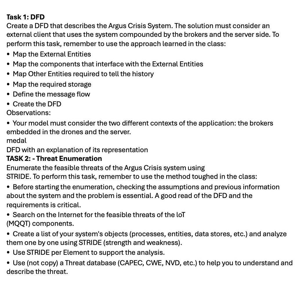
SEE TEXT FOR PROBLEM STATEMENT AND SEE ATTACHED IMAGE FOR TASKS 1 & 2 . Problem Statement Disaster ScenarioEvery year, disasters and crises devastate people,
SEE TEXT FOR PROBLEM STATEMENT AND SEE ATTACHED IMAGE FOR TASKS &
Problem Statement Disaster ScenarioEvery year, disasters and crises devastate people, communities, and entire societies worldwide. Worryingly, they are predicted to become more common in the future. Disasters can occur naturally eg tornadoes, hurricanes, earthquakes, floods, wildfires, mudslides, or drought or be humancaused eg mass shootings, chemical spills, or terrorist attacks Preparing for, responding to and recovering from disasters and traumatic events is essential to individuals and communities' behavioral health.When people experience a disaster, they may experience a variety of reactions, many of which are natural responses to challenging situations. Most people show resilience after a disaster. Resilience is the ability to bounce back, cope with adversity, and endure demanding conditions. Thankfully, resilience in disaster recovery is ordinary, not extraordinary, and people regularly demonstrate this ability. Supportive resources to address stress and other hardships are critical to resilience.Like war, disasters are also very unstructured in scope. No one can predict the exact time and how a disaster will strike. Sometimes, the local infrastructure is devasted, and there are no telecommunication resources available to provide essential communication necessities, such as means for the affected communities to ask for help. Usually, this type of situation requires a complete telecommunication infrastructure to provide Command and Control to support the operations.Figure Flooding west of Pittsburgh in the Oakdale area.We use a flooding scenario to support the course in the project development. Because the changes to our climate and environment are already contributing to the increased frequency, intensity, and unpredictability of severe weather events, what makes this type of disaster usually in different countries, generating many victims and causing fatalities and incalculable losses financial and social for the population. The Federal Emergency Management Agency stated, quoting NOAA data, that flooding caused more damage in the United States than any other severe weatherrelated event, an average of $$ billion a year. States such as Texas, New Jersey, and Florida dominated the top on the list created by NOAA and had the most flooding risk. Louisiana joined those states to monopolize the top while Pennsylvania, Oregon, South Carolina, and Virginia made brief appearances. The Gulf Coast states comprise almost half of the top mostatrisk counties.For example, in November of Santa Catarina, a state in the south of Brazil, had a period of heavy rainfall November The state had suffered constant rains for over two months, which turned the soil wet enough to cause a landslide during the storm that hit the state in late November. Around towns and over million people were affected. At least people have been killed, with over forced to evacuate their homes. A further have been left without electricity, while water rationing is being carried out in at least one town due to purification problems. Several regions cities have become cut off due to floodwater and landslide debris. Water levels in the Vale do Itaja have risen to eleven meters above normal. Because of the electrical blackout, many communities were left without communication, which made it difficult for people to call for help and inform where they were.Solution Description Argus CrisisThe problem to be answered is providing an efficient and secure environment to send a distress message when a natural disaster occurs in our case, the flood disaster situation In the scenario, there are no telecommunication links to provide essential communication voice and data to the rescue teams. Consequently, innovation is required. It uses the means existent in the community and by volunteers, for example, drones, to provide communication resources and support the identification of hazards.In this scenario, victims in the flood area will have a smartphone with a rescue app, which enables the citizens to send their position continuously and when they are in danger severity level message: high, medium, or low as a simple text message description of their situation as it is presented in Figure To provide communication support enabling victims messages to flow to the Crisis Management Center CMC drones flying in the crisis area intercept the message and forward it to other drones until the message arrives at the CMC The CMC data is processed and aggregated, and a dashboard is provided for the operators to plan the rescue operation efficiently. The approach used to implement the solution is through an Internet of Things IoT architecture. IoT is an advanced automation and analytics system that deals with artificial intelligence, sensors networking, electronics, cloud messaging, etc., to deliver complete systems for the product or services. A logical view of the technical architecture of the solution is presented in Figure There, you can see drones with phone devices, which periodically send MQTT messages to the Crisis Management Center through bridge brokers existent in drones, informing the severity and position of the user.An essential entity in this environment is the MQTT broker, which is implemented using Eclipse Mosquito embedded in drones Eclipse Mosquito is an opensource EPLEDL licensed message broker that implements the MQTT Mosquito is lightweight and suitable for all devices, from lowpower singleboard computers to full servers. The drone runs in bridge mode, which means it receives the messages from the user nodes and forwards them to the primary Broker at the Crisis Management Center see Figure Figure Argus Crise Message Flow Brokers The Crisis Management Center provides users with CommandandControl C features. It is a node that runs on a server box Linux or Windows This server has a Mosquito broker, which receives all messages from the bridge ones and persists them in an SQL database. Also, it has a dashboard that organizes the data in a helpful format, presents the information in a map visualization, and calculates the Risk KPI explained in the textAs we cited, the dashboard needs to present helpful information, including the geoinformation about the user nodes as the classification KPI calculated based on the severity sent. The formula to calculate the KPI is shown, and the color code is presented in the dashboard, which you can see in the following Figure. Figure Argus Crisis C Dashboard. As you commented, each node sends its state using MQTT to the bridge broker. The conditions can be low, middle, or high; where high, the individual is in danger, and low, he is safe. The dashboard needs to compile this data and, using the formula presented in the previous figure, define the risk situation and colorize the node representation in the map.

Step by Step Solution
There are 3 Steps involved in it
Step: 1

Get Instant Access to Expert-Tailored Solutions
See step-by-step solutions with expert insights and AI powered tools for academic success
Step: 2

Step: 3

Ace Your Homework with AI
Get the answers you need in no time with our AI-driven, step-by-step assistance
Get Started


