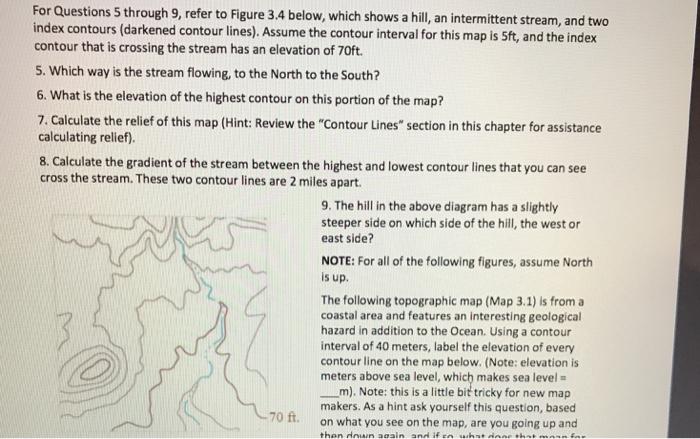
For Questions 5 through 9, refer to Figure 3.4 below, which shows a hill, an intermittent stream, and two index contours (darkened contour lines).

For Questions 5 through 9, refer to Figure 3.4 below, which shows a hill, an intermittent stream, and two index contours (darkened contour lines). Assume the contour interval for this map is 5ft, and the index contour that is crossing the stream has an elevation of 70ft. 5. Which way is the stream flowing, to the North to the South? 6. What is the elevation of the highest contour on this portion of the map? 7. Calculate the relief of this map (Hint: Review the "Contour Lines" section in this chapter for assistance calculating relief). 8. Calculate the gradient of the stream between the highest and lowest contour lines that you can see cross the stream. These two contour lines are 2 miles apart. 9. The hill in the above diagram has a slightly steeper side on which side of the hill, the west or east side? NOTE: For all of the following figures, assume North is up. The following topographic map (Map 3.1) is from a coastal area and features an interesting geological hazard in addition to the Ocean. Using a contour interval of 40 meters, label the elevation of every contour line on the map below. (Note: elevation is meters above sea level, which makes sea level = m). Note: this is a little bit tricky for new map makers. As a hint ask yourself this question, based on what you see on the map, are you going up and then down aeain and if en what inne shat 70 ft.
Step by Step Solution
3.46 Rating (153 Votes )
There are 3 Steps involved in it
Step: 1
Required solution of all parts is given below Ans 5 South The stream on the map flows towards ...
See step-by-step solutions with expert insights and AI powered tools for academic success
Step: 2

Step: 3

Ace Your Homework with AI
Get the answers you need in no time with our AI-driven, step-by-step assistance
Get Started


