Answered step by step
Verified Expert Solution
Question
1 Approved Answer
Would please answer the both two question? I would be so thankful and for sure I will give you 5 stars.t hank you for your
Would please answer the both two question? I would be so thankful and for sure I will give you 5 stars.t hank you for your time
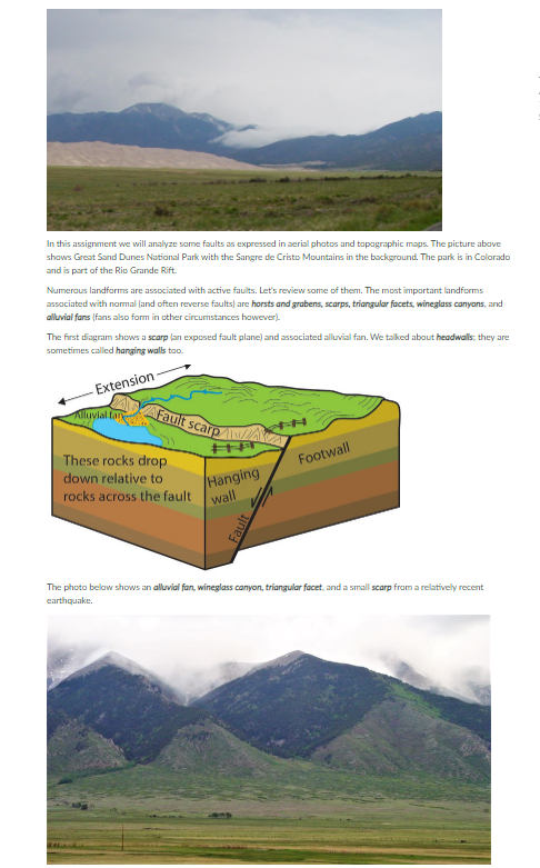
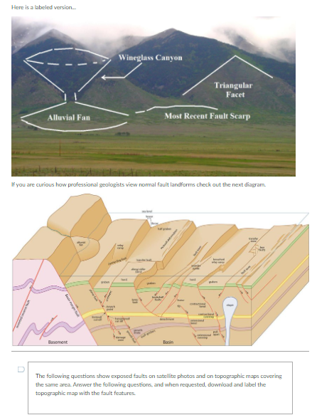
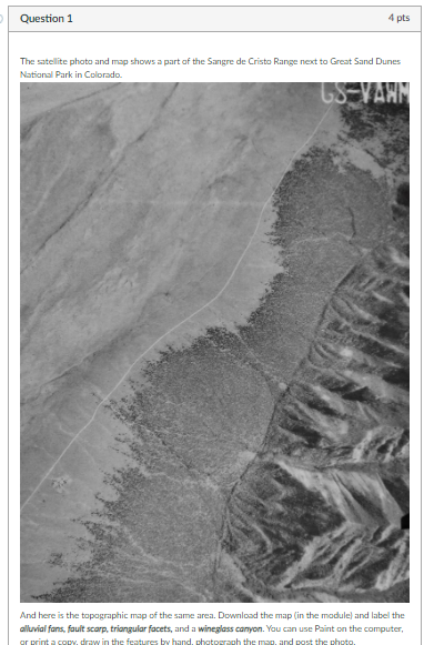
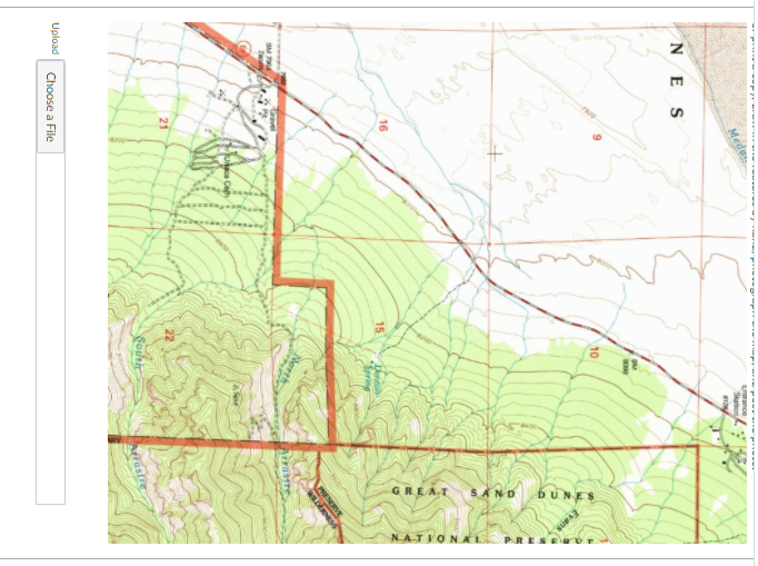
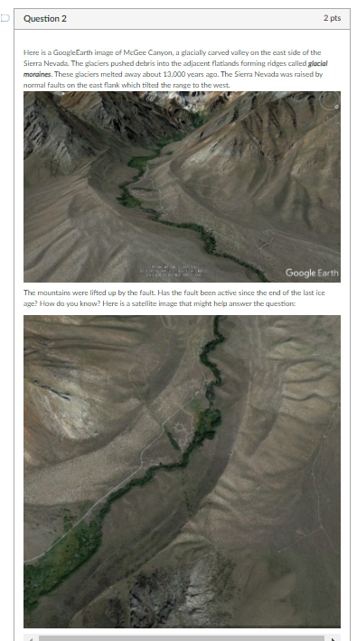
In this assignment we will analyze some faults as expressed in aerial photos and topographic maps. The picture above shows Great Sand Dunes National Park with the Sangre de Cristo Mountains in the background. The park is in Colorado and is part of the Rio Grande Rift. Numerous landforms are associated with active faults. Let's review some of them. The most important landforms associated with normal and often reverse faults) are horsts and grabens, scarps, triangular facets, wineglass canyons, and alluvial fons (fans also form in other circumstances however). The first diagram shows a scarplan exposed fault plane) and associated alluvial fan. We talked about headwalls: they are sometimes called hanging walls too. Extension fluvialtan Fault scarp Footwall These rocks drop down relative to rocks across the fault wall Hanging The photo below shows an alluvial fan, wineglass canyon, triangular facet, and a small scarp from a relatively recent earthquake Here is a labeled version. Wineglass Canyon Triangular Facet Alluvial Fan Most Recent Fault Scarp If you are curious how professional geologists view normal fault landforms check out the next diagram Basement Basin D The following questions show exposed faults on satellite photos and on topographic maps covering the same area. Answer the following questions, and when requested, download and label the topographic map with the fault features Question 1 4 pts The satellite photo and map shows a part of the Sangre de Cristo Range next to Great Sand Dunes National Park in Colorado US-VANN And here is the topographic map of the same area. Download the map (in the module) and label the alluvial fans.fault scarp. triangular facets, and a wineglass canyon. You can use Paint on the computer, ar print a copy, drow in the features by hand, chatograph the msg, and post the photo Lance Station NES Evans $ INYS GREAT NATVONAL Dento * SM . 21 Soler crestre Upload Choose a File Question 2 2 pts Here is a Google Earth image of McGee Canyon, a glacially carved valley on the east side of the Sierra Nevada. The glaciers pushed debris into the adjacent flatands forming ridges called glacial moraines. These glaciers melted away about 13,000 years ago. The Sierra Nevada was raised by normal faults on the east flank which tilted the range to the west. Google Earth The mountains were lifted up by the fault. Has the fault been active since the end of the last ice age? How do you know? Here is a satellite image that might help answer the question In this assignment we will analyze some faults as expressed in aerial photos and topographic maps. The picture above shows Great Sand Dunes National Park with the Sangre de Cristo Mountains in the background. The park is in Colorado and is part of the Rio Grande Rift. Numerous landforms are associated with active faults. Let's review some of them. The most important landforms associated with normal and often reverse faults) are horsts and grabens, scarps, triangular facets, wineglass canyons, and alluvial fons (fans also form in other circumstances however). The first diagram shows a scarplan exposed fault plane) and associated alluvial fan. We talked about headwalls: they are sometimes called hanging walls too. Extension fluvialtan Fault scarp Footwall These rocks drop down relative to rocks across the fault wall Hanging The photo below shows an alluvial fan, wineglass canyon, triangular facet, and a small scarp from a relatively recent earthquake Here is a labeled version. Wineglass Canyon Triangular Facet Alluvial Fan Most Recent Fault Scarp If you are curious how professional geologists view normal fault landforms check out the next diagram Basement Basin D The following questions show exposed faults on satellite photos and on topographic maps covering the same area. Answer the following questions, and when requested, download and label the topographic map with the fault features Question 1 4 pts The satellite photo and map shows a part of the Sangre de Cristo Range next to Great Sand Dunes National Park in Colorado US-VANN And here is the topographic map of the same area. Download the map (in the module) and label the alluvial fans.fault scarp. triangular facets, and a wineglass canyon. You can use Paint on the computer, ar print a copy, drow in the features by hand, chatograph the msg, and post the photo Lance Station NES Evans $ INYS GREAT NATVONAL Dento * SM . 21 Soler crestre Upload Choose a File Question 2 2 pts Here is a Google Earth image of McGee Canyon, a glacially carved valley on the east side of the Sierra Nevada. The glaciers pushed debris into the adjacent flatands forming ridges called glacial moraines. These glaciers melted away about 13,000 years ago. The Sierra Nevada was raised by normal faults on the east flank which tilted the range to the west. Google Earth The mountains were lifted up by the fault. Has the fault been active since the end of the last ice age? How do you know? Here is a satellite image that might help answer theStep by Step Solution
There are 3 Steps involved in it
Step: 1

Get Instant Access to Expert-Tailored Solutions
See step-by-step solutions with expert insights and AI powered tools for academic success
Step: 2

Step: 3

Ace Your Homework with AI
Get the answers you need in no time with our AI-driven, step-by-step assistance
Get Started


