Question: Old Troy Road 1/2 |- 80% + Marlboro Shaker ======= Road 1400 To RL 124 1600 1700 N.H. DIVISION OF PARKS & RECREATION DEPT.


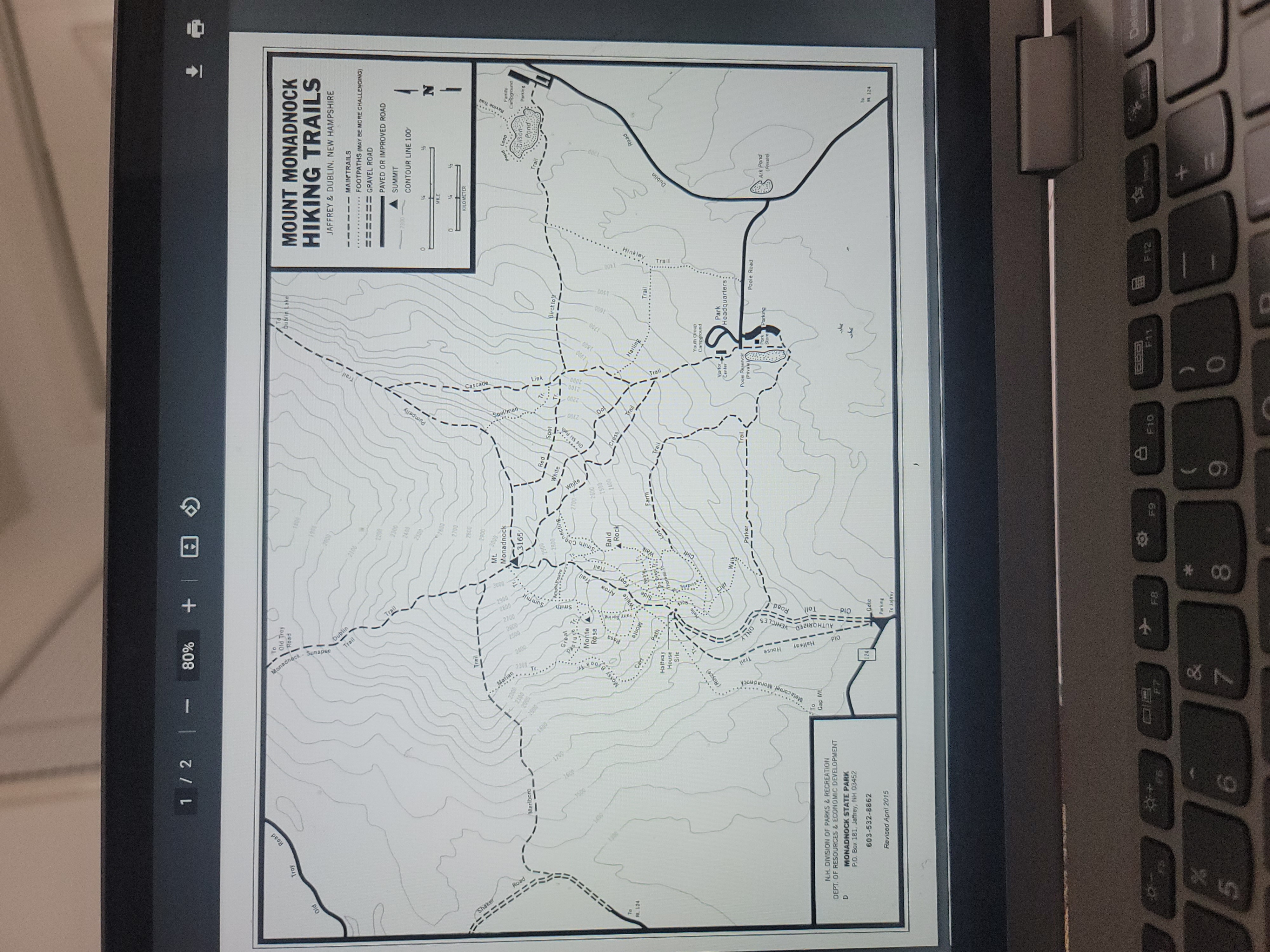
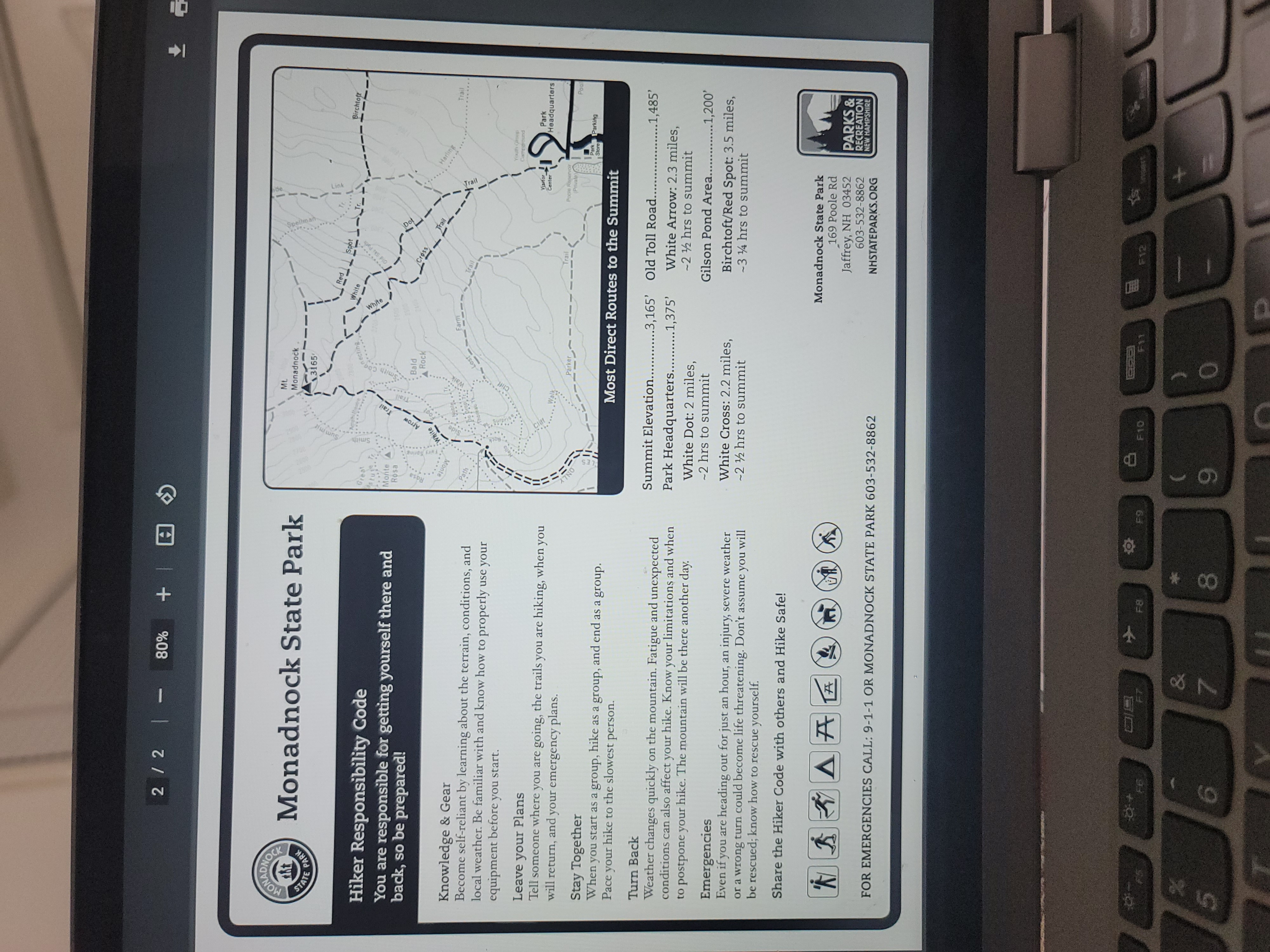
Old Troy Road 1/2 |- 80% + Marlboro Shaker ======= Road 1400 To RL 124 1600 1700 N.H. DIVISION OF PARKS & RECREATION DEPT. OF RESOURCES & ECONOMIC DEVELOPMENT D MONADNOCK STATE PARK P.O. Box 181, Jaffrey, NH 03452 603-532-8862 Revised April 2015 To Old Troy Road 1800 1900 2000 Monadnock-Sunapee Dublin Trail Trail Marian 2200 2100 2000 1900 1800- Mossy 15 Trail 2300- 2400 Great Pasture. To Monte Rosa Cart Path Halfway (Royce) Melk To Gap ML 5 7 House Site NO Summit Smith 2100 2200 2300 2400 2500 2600 2700 2800 2900 Mt. 3000 Monadnock 3165 Pumpelly Trail Red White Spot Old Ski Path 2900 2800- necting Bald Rock 2700 2600 2500 2400 White White Arrow Foot Trail Fairy Sprin Noble. Hello Thore Plo Halfway AUTHORIZED == Toll House 111 VEHICL Road PIO 124 Gate Y Parking To Jajey Cliff F8 Walk * 00 8 Walk Spellman Dot Cross Trail Farm Trail Trail Parker F9 22001 Cascade Link 2100. Visifor Center 0061 1800 Harling Poole Reservoir (Private) Dublin Lake MOUNT MONADNOCK HIKING TRAILS JAFFREY & DUBLIN, NEW HAMPSHIRE MAIN TRAILS FOOTPATHS (MAY BE MORE CHALLENGING) GRAVEL ROAD PAVED OR IMPROVED ROAD 1700 Birchtoft DOS 0091 Trail Youth Group Carreground Park Headquarters 1400 Trail Poole Road Park Parking Store a F10 F11 0 F12 SUMMIT 2300 CONTOUR LINE 100 MILE 0 36 HILOMETER Dublin 45 Pond Trail Loop Gilson Pond Ark Pond (Private) Road Ravine Tr N Family Campground Parking RL 124 Delete ht STATE PARK 2/2- 80% + Monadnock State Park Great Hiker Responsibility Code You are responsible for getting yourself there and back, so be prepared! Monte Rosa Smith ww ML Monadnock 3165 Amphitheatre 2800 necting White Arrow Trail Red White Bald Rock 2600 2400 White Spot Old Ski Path Dot Cross Trail Harling Birchtotr Trail Knowledge & Gear Become self-reliant by learning about the terrain, conditions, and local weather. Be familiar with and know how to properly use your equipment before you start. Leave your Plans Tell someone where you are going, the trails you are hiking, when you will return, and your emergency plans. Stay Together When you start as a group, hike as a group, and end as a group. Pace your hike to the slowest person. Turn Back Weather changes quickly on the mountain. Fatigue and unexpected conditions can also affect your hike. Know your limitations and when to postpone your hike. The mountain will be there another day. Emergencies Even if you are heading out for just an hour, an injury, severe weather or a wrong turn could become life threatening. Don't assume you will be rescued; know how to rescue yourself. Share the Hiker Code with others and Hike Safe! Path 7NO Thoreau Walk Walk Parker Farm Trail Trail Visitor Center Poole Reservoir (Private) Most Direct Routes to the Summit Summit Elevation....... Park Headquarters. White Dot: 2 miles, -2 hrs to summit White Cross: 2.2 miles, -22 hrs to summit .3,165' Old Toll Road.. 1,375' Youth Group Campground Park Headquarters Park Parking Store Pool .........1,485' White Arrow: 2.3 miles, -2 hrs to summit Gilson Pond Area..............1,200' Birchtoft/Red Spot: 3.5 miles, -34 hrs to summit 'N B A FOR EMERGENCIES CALL: 9-1-1 OR MONADNOCK STATE PARK 603-532-8862 4+ 29 7 F8 * 8 00 Monadnock State Park 169 Poole Rd Jaffrey, NH 03452 603-532-8862 NHSTATEPARKS.ORG PARKS & RECREATION NEW HAMPSHIRE F9 F10 F12 9 1/2 | - 90% + For this lab, we'll be looking at a topographical map of Mount Monadnock. You can use the pdf online, or the attached screenshot. You aren't going to be using any Calc III calculating, just a bit of trig and algebra, oh and some vector notation. The lines of equal elevation are marked and labeled in grey. They are given every 100 ft on this particular map. A scale is given on the right, with units in both miles and kilometers. 1. a) Standing on top of the mountain (black triangle), what is the direction vector with the steepest slope from the peak to the 2500' level? b) What is the average slope in that direction? (Be careful of units!) And what is your average angle of descent? c) If the slope were constant and the trail straight in that direction (if there was a trail) what would the length of the trail be? 2. a) Going from the peak to the 3000' level, in which direction is the slope the least steep? Mark that point 'a'. b) From point a, in which direction is it least steep to get to the 2900' level? Mark that point 'b'. c) From point b, in which direction is it least steep to get to the 2800' level? Mark that point 'c'. F9 2/2- 90% + d) If you were going all the way from the peak directly to the 2800' level (i.e. traveling in a straight line), in which direction is it the least steep? Mark that point 'd'. e) Are points 'c' and 'd' in the same place? If so, do you think this would always be the case? Can you illustrate your assertion? 3. Along which trail - Marlboro, Dublin, Pumpelly, White Arrow, or White Cross - is the trail steepest in going from 2900 ft to 2500 ft? 4. Which trail has uphill stretches (a rise of at least 100 ft) even as you are making your descent? 5. What is the approximate change in elevation if you go from the peak and head due North for 1 kilometer?
Step by Step Solution
There are 3 Steps involved in it
Lets tackle these questions step by step 1 Analyzing the Direction and Slope a Direction vector from ... View full answer

Get step-by-step solutions from verified subject matter experts


