

Answered step by step
Verified Expert Solution
Question
1 Approved Answer
A marine surveyor uses a rangefinder and a compass to locate a ship and an island in the vicinity of the coast on which
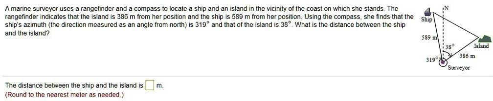
A marine surveyor uses a rangefinder and a compass to locate a ship and an island in the vicinity of the coast on which she stands. The rangefinder indicates that the island is 386 m from her position and the ship is 589 m from her position. Using the compass, she finds that the ship's azimuth (the direction measured as an angle from north) is 319 and that of the island is 38. What is the distance between the ship and the island? Ship 589 m The distance between the ship and the island is (Round to the nearest meter as needed.) m. 319 38 386 m Surveyor Island
Step by Step Solution
There are 3 Steps involved in it
Step: 1

Get Instant Access to Expert-Tailored Solutions
See step-by-step solutions with expert insights and AI powered tools for academic success
Step: 2

Step: 3
Ace Your Homework with AI
Get the answers you need in no time with our AI-driven, step-by-step assistance
Get Started
Roads To Geometry
Authors: Edward C Wallace, Stephen F West
3rd Edition
1478632038, 9781478632030