

Answered step by step
Verified Expert Solution
Question
1 Approved Answer
Hi, I need a uml diagram that illustrates the flow of this assignment. Lab Assignment 3 The Coordinate Distance Calculator Due Date (a two-week LA)
Hi, I need a uml diagram that illustrates the flow of this assignment.
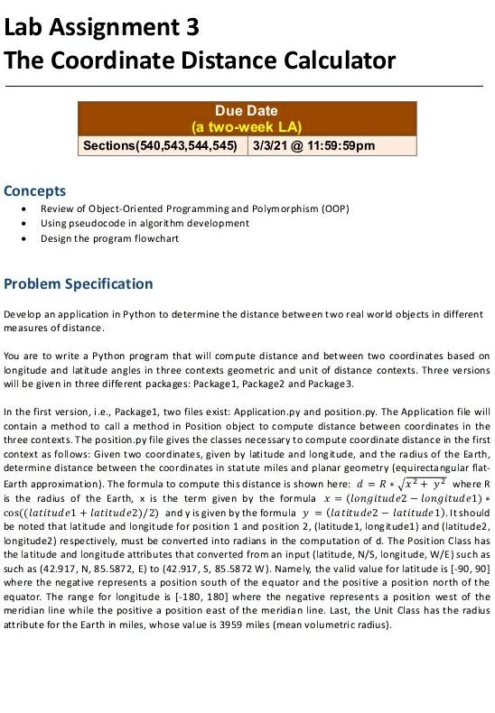
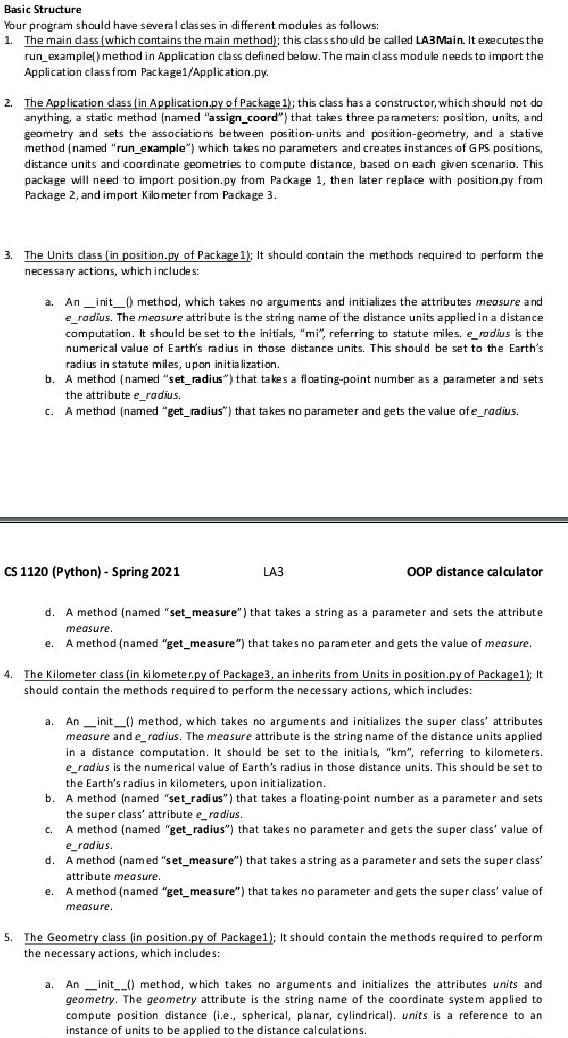
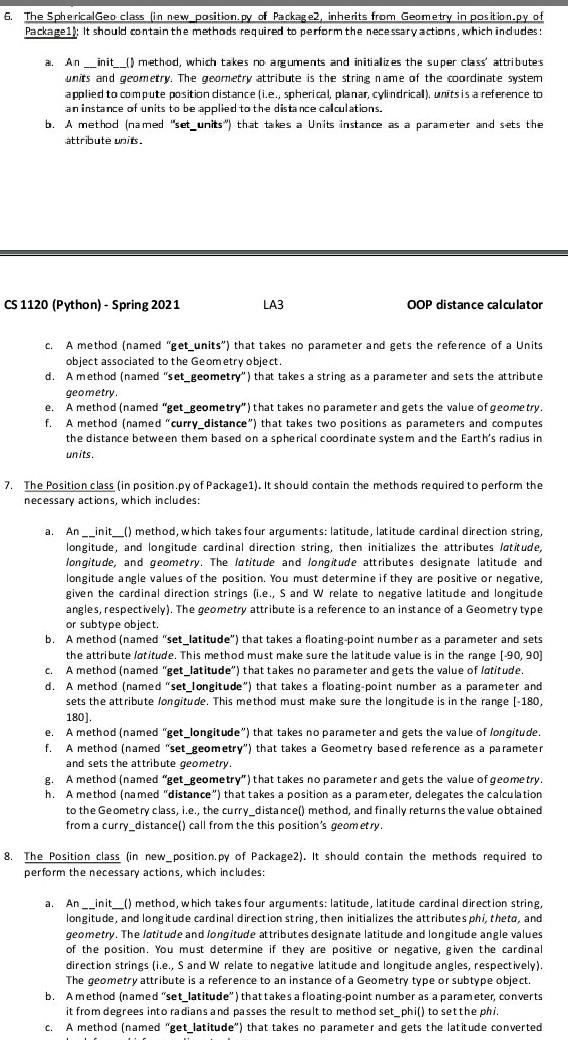
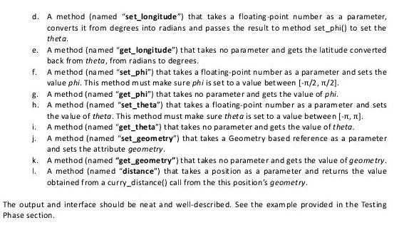
Lab Assignment 3 The Coordinate Distance Calculator Due Date (a two-week LA) Sections(540,543,544,545) 3/3/21 @ 11:59:59pm Concepts Review of Object-Oriented Programming and Polymorphism (OOP) Using pseudocode in algorithm development Design the program flowchart Problem Specification Develop an application in Python to determine the distance between two real world objects in different measures of distance. You are to write a Python program that will compute distance and between two coordinates based on longitude and latitude angles in three contexts geometric and unit of distance contexts. Three versions will be given in three different packages: Package 1, Package2 and Package 3. In the first version, i.e., Package1, two files exist: Application.py and position.py. The Application file will contain a method to call a method in Position object to compute distance between coordinates in the three contexts. The position.py file gives the classes necessary to compute coordinate distance in the first context as follows: Given two coordinates, given by latitude and longitude, and the radius of the Earth, determine distance between the coordinates in statute miles and planar geometry (equirectangular flat- Earth approximation). The formula to compute this distance is shown here: d = R./x2 + y2 where R is the radius of the Earth, x is the term given by the formula x = (longitude2 - longitudel). cos((latitudel + latitude2)/2) and y is given by the formula y = (latitude2 - latitude 1). It should be noted that latitude and longitude for position 1 and position 2, (latitude 1, long it udel) and (latitude2, longitude2) respectively, must be converted into radians in the computation of d. The Position Class has the latitude and longitude attributes that converted from an input (latitude, N/S, longitude, W/E) such as such as (42.917, N, 85.5872, E) to (42.917, S, 85.5872 W). Namely, the valid value for latitude is (-90, 90] where the negative represents a position south of the equator and the positive a position north of the equator. The range for longitude is (-180, 180] where the negative represents a position west of the meridian line while the positive a position east of the meridian line. Last, the Unit Class has the radius attribute for the Earth in miles, whose value is 3959 miles (mean volumetric radius). Basic Structure Your program should have several classes in different modules as follows: 1. The main dass (which contains the main method); this class should be called LA3Main. It executesthe run_example() method in Application class defined below. The main class module needs to import the Application classfrom Package1/Application.py. 2. The Application dass (in Application.py of Package 1); this class has a constructor, which should not do anything, a static method (named "assign_coord") that takes three parameters: position, units, and geometry and sets the associations between position units and position-geometry, and a stative method (named "run_example") which takes no parameters and creates instances of GPS positions, distance units and coordinate geometries to compute distance, based on each given scenario. This package will need to import position.py from Package 1, then later replace with position.py from Package 2, and import Kilometer from Package 3. 3. The Units class (in position.py of Package 1); It should contain the methods required to perform the necessary actions, which includes: a. An _init_() method, which takes no arguments and initializes the attributes measure and e_radius. The measure attribute is the string name of the distance units applied in a distance computation. It should be set to the initials, "mi", referring to statute miles. e_rodius is the numerical value of Earth's radius in those distance units. This should be set to the Earth's radius in statute miles, upon initialization. b. A method (named "set_radius") that takes a floating-point number as a parameter and sets the attribute e_radius. C. A method (named "get_radius") that takes no parameter and gets the value ofe_radius. CS 1120 (Python) - Spring 2021 LA3 OOP distance calculator d. A method (named "set_measure") that takes a string as a parameter and sets the attribute measure. e. A method (named "get_measure") that takes no parameter and gets the value of measure. 4. The Kilometer class (in kilometer.py of Package3, an inherits from Units in position.py of Packagel); It should contain the methods required to perform the necessary actions, which includes: a. An __init__() method, which takes no arguments and initializes the super class' attributes measure and e_radius. The measure attribute is the string name of the distance units applied in a distance computation. It should be set to the initials, "km", referring to kilometers. e_radius is the numerical value of Earth's radius in those distance units. This should be set to the Earth's radius in kilometers, upon initialization. b. A method (named "set_radius") that takes a floating point number as a parameter and sets the super class' attribute e_radius. c. A method (named "get_radius") that takes no parameter and gets the super class' value of e_radius. d. A method (named "set_measure") that takes a string as a parameter and sets the super class' attribute measure e. A method (named "get_measure") that takes no parameter and gets the super class' value of measure 5. The Geometry class (in position.py of Packagel); It should contain the methods required to perform the necessary actions, which includes: a. An _init__() method, which takes no arguments and initializes the attributes units and geometry. The geometry attribute is the string name of the coordinate system applied to compute position distance (i.e., spherical, planar, cylindrical). units is a reference to an instance of units to be applied to the distance calculations. 6. The SphericalGeo class in new_position.py of Package, inherits from Geometry in position.py of Package1): It should contain the methods required to perform the necessary actions, which indudes: a. An __init__() method, which takes no arguments and initializes the super class' attributes units and geometry. The geometry attribute is the string name of the coordinate system applied to compute position distance i.e., spherical, planar, cylindrical) units is a reference to an instance of units to be applied to the distance calculations. b. A method (named "set_units") that takes a Units instance as a parameter and sets the attribute units. CS 1120 (Python) - Spring 2021 LA3 OOP distance calculator c. A method (named "get_units") that takes no parameter and gets the reference of a Units object associated to the Geometry object. d. Amethod (named "set_geometry") that takes a string as a parameter and sets the attribute geometry. e. A method (named "get_geometry") that takes no parameter and gets the value of geometry. f. A method (named "curry_distance") that takes two positions as parameters and computes the distance between them based on a spherical coordinate system and the Earth's radius in units. 7. The Position class (in position.py of Packagel). It should contain the methods required to perform the necessary actions, which includes: a. An __init_() method, which takes four arguments: latitude, latitude cardinal direction string, longitude, and longitude cardinal direction string, then initializes the attributes latitude, longitude, and geometry. The latitude and longitude attributes designate latitude and longitude angle values of the position. You must determine if they are positive or negative, given the cardinal direction strings (i.e., S and W relate to negative latitude and longitude angles, respectively). The geometry attribute is a reference to an instance of a Geometry type or subtype object b. A method (named "set_latitude") that takes a floating point number as a parameter and sets the attribute latitude. This method must make sure the latitude value is in the range (-90, 90] C. A method (named "get_latitude") that takes no parameter and gets the value of latitude. d. A method (named "set_longitude") that takes a floating point number as a parameter and sets the attribute longitude. This method must make sure the longitude is in the range (-180, 180) e. A method (named "get_longitude") that takes parameter and gets the value of longitude. f. A method (named "set_geometry") that takes a Geometry based reference as a parameter and sets the attribute geometry. g. A method (named "get_geometry") that takes no parameter and gets the value of geometry. h. A method (named "distance") that takes a position as a parameter, delegates the calculation to the Geometry class, i.e., the curry_distance() method, and finally returns the value obtained from a curry_distance() call from the this position's geometry, 8. The Position class (in new_position.py of Package2). It should contain the methods required to perform the necessary actions, which includes: a. An __init_() method, which takes four arguments: latitude, latitude cardin al direction string, longitude, and long itude cardinal direction string, then initializes the attributes phi, theta, and geometry. The latitude and longitude attributes designate latitude and longitude angle values of the position. You must determine if they are positive or negative, given the cardinal direction strings (ie., S and W relate to negative latitude and longitude angles, respectively) The geometry attribute is a reference to an instance of a Geometry type or subtype object. b. A method (named "set_latitude") that takes a floating-point number as a parameter, converts it from degrees into radians and passes the result to method set_phil) to set the phi. c. A method (named "get_latitude") that takes no parameter and gets the latitude converted d. A method (named "set_longitude") that takes a floating point number as a parameter, converts it from degrees into radians and passes the result to method set_phi() to set the theta. e. A method (named "get_longitude") that takes no parameter and gets the latitude converted back from theta, from radians to degrees. f. A method (named "set_phi") that takes a floating point number as a parameter and sets the value phi. This method must make sure phi is set to a value between (-1/2, 1/2). g. A method (named "get_phi") that takes no parameter and gets the value of phi. h. A method (named "set_theta") that takes a floating-point number as a parameter and sets the value of theta. This method must make sure theta is set to a value between [-IT, T). 1. A method (named "get_the ta") that takes no parameter and gets the value of theta. J. A method (named "set_geometry") that takes a Geometry based reference as a parameter and sets the attribute geometry. k. A method (named "get_geometry") that takes no parameter and gets the value of geometry. 1. A method (named "distance") that takes a position as a parameter and returns the value obtained from a curry_distance() call from the this position's geometry. The output and interface should be neat and well-described. See the example provided in the Testing Phase section Lab Assignment 3 The Coordinate Distance Calculator Due Date (a two-week LA) Sections(540,543,544,545) 3/3/21 @ 11:59:59pm Concepts Review of Object-Oriented Programming and Polymorphism (OOP) Using pseudocode in algorithm development Design the program flowchart Problem Specification Develop an application in Python to determine the distance between two real world objects in different measures of distance. You are to write a Python program that will compute distance and between two coordinates based on longitude and latitude angles in three contexts geometric and unit of distance contexts. Three versions will be given in three different packages: Package 1, Package2 and Package 3. In the first version, i.e., Package1, two files exist: Application.py and position.py. The Application file will contain a method to call a method in Position object to compute distance between coordinates in the three contexts. The position.py file gives the classes necessary to compute coordinate distance in the first context as follows: Given two coordinates, given by latitude and longitude, and the radius of the Earth, determine distance between the coordinates in statute miles and planar geometry (equirectangular flat- Earth approximation). The formula to compute this distance is shown here: d = R./x2 + y2 where R is the radius of the Earth, x is the term given by the formula x = (longitude2 - longitudel). cos((latitudel + latitude2)/2) and y is given by the formula y = (latitude2 - latitude 1). It should be noted that latitude and longitude for position 1 and position 2, (latitude 1, long it udel) and (latitude2, longitude2) respectively, must be converted into radians in the computation of d. The Position Class has the latitude and longitude attributes that converted from an input (latitude, N/S, longitude, W/E) such as such as (42.917, N, 85.5872, E) to (42.917, S, 85.5872 W). Namely, the valid value for latitude is (-90, 90] where the negative represents a position south of the equator and the positive a position north of the equator. The range for longitude is (-180, 180] where the negative represents a position west of the meridian line while the positive a position east of the meridian line. Last, the Unit Class has the radius attribute for the Earth in miles, whose value is 3959 miles (mean volumetric radius). Basic Structure Your program should have several classes in different modules as follows: 1. The main dass (which contains the main method); this class should be called LA3Main. It executesthe run_example() method in Application class defined below. The main class module needs to import the Application classfrom Package1/Application.py. 2. The Application dass (in Application.py of Package 1); this class has a constructor, which should not do anything, a static method (named "assign_coord") that takes three parameters: position, units, and geometry and sets the associations between position units and position-geometry, and a stative method (named "run_example") which takes no parameters and creates instances of GPS positions, distance units and coordinate geometries to compute distance, based on each given scenario. This package will need to import position.py from Package 1, then later replace with position.py from Package 2, and import Kilometer from Package 3. 3. The Units class (in position.py of Package 1); It should contain the methods required to perform the necessary actions, which includes: a. An _init_() method, which takes no arguments and initializes the attributes measure and e_radius. The measure attribute is the string name of the distance units applied in a distance computation. It should be set to the initials, "mi", referring to statute miles. e_rodius is the numerical value of Earth's radius in those distance units. This should be set to the Earth's radius in statute miles, upon initialization. b. A method (named "set_radius") that takes a floating-point number as a parameter and sets the attribute e_radius. C. A method (named "get_radius") that takes no parameter and gets the value ofe_radius. CS 1120 (Python) - Spring 2021 LA3 OOP distance calculator d. A method (named "set_measure") that takes a string as a parameter and sets the attribute measure. e. A method (named "get_measure") that takes no parameter and gets the value of measure. 4. The Kilometer class (in kilometer.py of Package3, an inherits from Units in position.py of Packagel); It should contain the methods required to perform the necessary actions, which includes: a. An __init__() method, which takes no arguments and initializes the super class' attributes measure and e_radius. The measure attribute is the string name of the distance units applied in a distance computation. It should be set to the initials, "km", referring to kilometers. e_radius is the numerical value of Earth's radius in those distance units. This should be set to the Earth's radius in kilometers, upon initialization. b. A method (named "set_radius") that takes a floating point number as a parameter and sets the super class' attribute e_radius. c. A method (named "get_radius") that takes no parameter and gets the super class' value of e_radius. d. A method (named "set_measure") that takes a string as a parameter and sets the super class' attribute measure e. A method (named "get_measure") that takes no parameter and gets the super class' value of measure 5. The Geometry class (in position.py of Packagel); It should contain the methods required to perform the necessary actions, which includes: a. An _init__() method, which takes no arguments and initializes the attributes units and geometry. The geometry attribute is the string name of the coordinate system applied to compute position distance (i.e., spherical, planar, cylindrical). units is a reference to an instance of units to be applied to the distance calculations. 6. The SphericalGeo class in new_position.py of Package, inherits from Geometry in position.py of Package1): It should contain the methods required to perform the necessary actions, which indudes: a. An __init__() method, which takes no arguments and initializes the super class' attributes units and geometry. The geometry attribute is the string name of the coordinate system applied to compute position distance i.e., spherical, planar, cylindrical) units is a reference to an instance of units to be applied to the distance calculations. b. A method (named "set_units") that takes a Units instance as a parameter and sets the attribute units. CS 1120 (Python) - Spring 2021 LA3 OOP distance calculator c. A method (named "get_units") that takes no parameter and gets the reference of a Units object associated to the Geometry object. d. Amethod (named "set_geometry") that takes a string as a parameter and sets the attribute geometry. e. A method (named "get_geometry") that takes no parameter and gets the value of geometry. f. A method (named "curry_distance") that takes two positions as parameters and computes the distance between them based on a spherical coordinate system and the Earth's radius in units. 7. The Position class (in position.py of Packagel). It should contain the methods required to perform the necessary actions, which includes: a. An __init_() method, which takes four arguments: latitude, latitude cardinal direction string, longitude, and longitude cardinal direction string, then initializes the attributes latitude, longitude, and geometry. The latitude and longitude attributes designate latitude and longitude angle values of the position. You must determine if they are positive or negative, given the cardinal direction strings (i.e., S and W relate to negative latitude and longitude angles, respectively). The geometry attribute is a reference to an instance of a Geometry type or subtype object b. A method (named "set_latitude") that takes a floating point number as a parameter and sets the attribute latitude. This method must make sure the latitude value is in the range (-90, 90] C. A method (named "get_latitude") that takes no parameter and gets the value of latitude. d. A method (named "set_longitude") that takes a floating point number as a parameter and sets the attribute longitude. This method must make sure the longitude is in the range (-180, 180) e. A method (named "get_longitude") that takes parameter and gets the value of longitude. f. A method (named "set_geometry") that takes a Geometry based reference as a parameter and sets the attribute geometry. g. A method (named "get_geometry") that takes no parameter and gets the value of geometry. h. A method (named "distance") that takes a position as a parameter, delegates the calculation to the Geometry class, i.e., the curry_distance() method, and finally returns the value obtained from a curry_distance() call from the this position's geometry, 8. The Position class (in new_position.py of Package2). It should contain the methods required to perform the necessary actions, which includes: a. An __init_() method, which takes four arguments: latitude, latitude cardin al direction string, longitude, and long itude cardinal direction string, then initializes the attributes phi, theta, and geometry. The latitude and longitude attributes designate latitude and longitude angle values of the position. You must determine if they are positive or negative, given the cardinal direction strings (ie., S and W relate to negative latitude and longitude angles, respectively) The geometry attribute is a reference to an instance of a Geometry type or subtype object. b. A method (named "set_latitude") that takes a floating-point number as a parameter, converts it from degrees into radians and passes the result to method set_phil) to set the phi. c. A method (named "get_latitude") that takes no parameter and gets the latitude converted d. A method (named "set_longitude") that takes a floating point number as a parameter, converts it from degrees into radians and passes the result to method set_phi() to set the theta. e. A method (named "get_longitude") that takes no parameter and gets the latitude converted back from theta, from radians to degrees. f. A method (named "set_phi") that takes a floating point number as a parameter and sets the value phi. This method must make sure phi is set to a value between (-1/2, 1/2). g. A method (named "get_phi") that takes no parameter and gets the value of phi. h. A method (named "set_theta") that takes a floating-point number as a parameter and sets the value of theta. This method must make sure theta is set to a value between [-IT, T). 1. A method (named "get_the ta") that takes no parameter and gets the value of theta. J. A method (named "set_geometry") that takes a Geometry based reference as a parameter and sets the attribute geometry. k. A method (named "get_geometry") that takes no parameter and gets the value of geometry. 1. A method (named "distance") that takes a position as a parameter and returns the value obtained from a curry_distance() call from the this position's geometry. The output and interface should be neat and well-described. See the example provided in the Testing Phase
Step by Step Solution
There are 3 Steps involved in it
Step: 1

Get Instant Access to Expert-Tailored Solutions
See step-by-step solutions with expert insights and AI powered tools for academic success
Step: 2

Step: 3
Ace Your Homework with AI
Get the answers you need in no time with our AI-driven, step-by-step assistance
Get Started
Database Systems For Advanced Applications Dasfax 2009 International Workshops Benchmark Mcis Wdpp Ppda Mbc Phd Brisbane Australia April 2009 Lncs 5667
Authors: Lei Chen ,Chengfei Liu ,Qing Liu ,Ke Deng
2009th Edition
364204204X, 978-3642042041