Answered step by step
Verified Expert Solution
Question
1 Approved Answer
i. You have been asked to establish a control network at UniSQ Toowoomba Campus for topographical mapping of campus area located near the Soccer

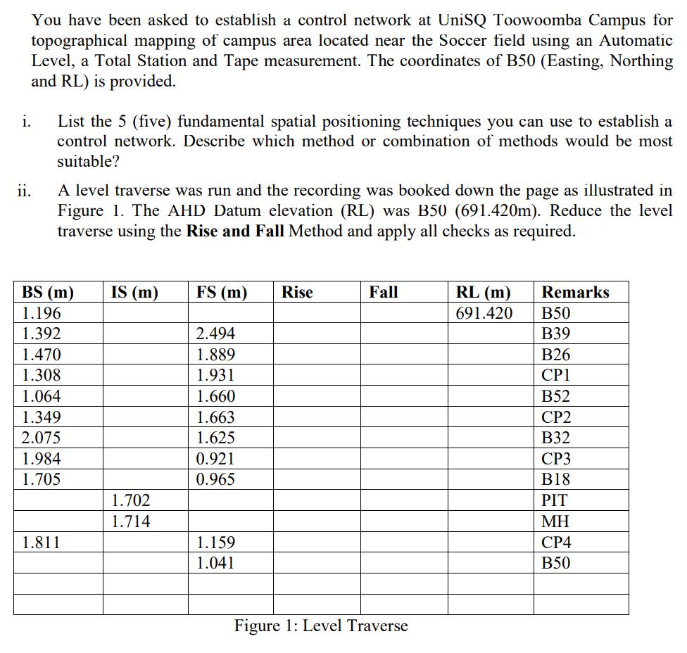
i. You have been asked to establish a control network at UniSQ Toowoomba Campus for topographical mapping of campus area located near the Soccer field using an Automatic Level, a Total Station and Tape measurement. The coordinates of B50 (Easting, Northing and RL) is provided. ii. List the 5 (five) fundamental spatial positioning techniques you can use to establish a control network. Describe which method or combination of methods would be most suitable? A level traverse was run and the recording was booked down the page as illustrated in Figure 1. The AHD Datum elevation (RL) was B50 (691.420m). Reduce the level traverse using the Rise and Fall Method and apply all checks as required. BS (m) 1.196 1.392 1.470 1.308 1.064 1.349 2.075 1.984 1.705 1.811 IS (m) 1.702 1.714 FS (m) 2.494 1.889 1.931 1.660 1.663 1.625 0.921 0.965 1.159 1.041 Rise Fall Figure 1: Level Traverse RL (m) 691.420 Remarks B50 B39 B26 CP1 B52 CP2 B32 CP3 B18 PIT CP4 B50
Step by Step Solution
★★★★★
3.54 Rating (157 Votes )
There are 3 Steps involved in it
Step: 1
Step 12 Solution Step 1 i Five methods to establish a control network are 1 Chain Traversing 2 Compa...
Get Instant Access to Expert-Tailored Solutions
See step-by-step solutions with expert insights and AI powered tools for academic success
Step: 2

Step: 3

Ace Your Homework with AI
Get the answers you need in no time with our AI-driven, step-by-step assistance
Get Started


