Answered step by step
Verified Expert Solution
Question
1 Approved Answer
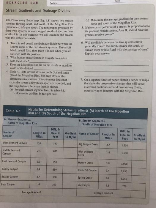
EXERCISE 13 B Section Stream Gradients and Drainage Divides The Promontory Butte map (fig. 4.8) shows two stream systems flowing north and south of


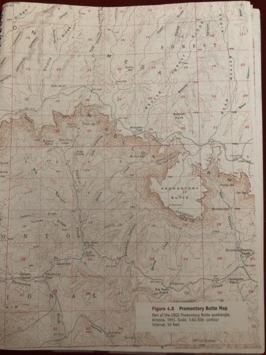
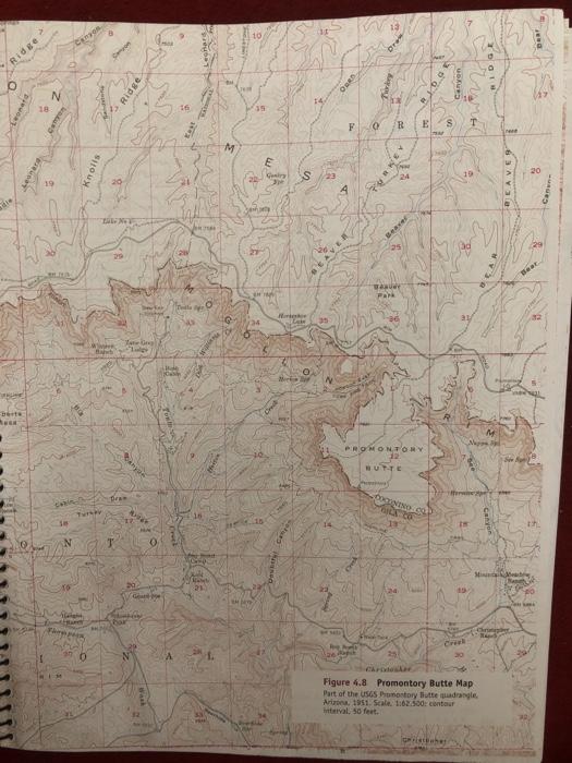
EXERCISE 13 B Section Stream Gradients and Drainage Divides The Promontory Butte map (fig. 4.8) shows two stream systems flowing north and south of the Mogollon Rim (pronounced Mo-gee-yone). The topography produced by these two systems is more rugged south of the rim than north of it. In this exercise, we will examine the reason why this difference exists. 1. Trace in red pencil the drainage divide between the source areas of the two stream systems. Use a soft black pencil first, then trace it in red when you are satisfied with its position. 2. What human-made feature is roughly coincident with the divide? 3. Does the Mogollon Rim lie on the divide or north or south of the divide? 4. Table 4.1 lists several streams north (A) and south (B) of the Mogollon Rim. For each stream, the differences in elevation of two contour lines that cross the stream a few miles apart are recorded, and the map distance between them is shown. (a) For each stream segment listed in table 4.1. calculate its gradient in feet per mile. Table 4.1 A. Stream Gradients, North of Mogollon Rim Name of Stream West Leonard Canyon Middle Leonard Canyon East Leonard Canyon Turkey Canyon Beaver Canyon Bear Canyon Matrix for Determining Stream Gradients (A) North of the Mogollon Rim and (B) South of the Mogollon Rim B. Stream Gradients, South of Mogollon Rim Diff. in Diff. in Elev. in Gradient Name of Stream Length in in ft/mi Elev. in Feet Miles Feet 250 Big Canyon Creek 3.7 1,500 400 1.8 Dick Williams Creek 1,150 250 Horton Creek 3.0 1,000 250 Doubtful Canyon 2.4 1.250 300 Spring Creek 2.2 1,250 200 See Canyon 2.2 700 Average Gradient. Length in Miles 2.6 2.4 Date (b) Determine the average gradient for the streams north and south of the Mogollon Rim. 5. If the erosive potential of a stream is proportional to its gradient, which system. A or B. should have the greatest erosive power? 6. Will the divide between the two systems move generally toward the north, toward the south, or remain more or less fixed with the passage of time? Explain your answer. 7. On a separate sheet of paper, sketch a series of maps that show the progressive changes that will occur as erosion continues around Promontory Butte, especially at its juncture with the Mogollon Rim. 1.9 1.9 3.7 1.6 Average Gradient Gradient in ft/mi AFTE Ridge N Debi 38 N Turkay Knalis Tes T Ridge krige 0 16 SME Camp BA CANE w. JA Hongko K F 0 B E 016 BA Park PROMONTORY BUTTE COCONINO CO ROCK 20 BEAR BEAVEY 1 Napps H Jay 26 d Creek 30 Christenker Figure 4.8 Promontory Butte Map Part of the USGS Promontory lutte quadrangle Arizona, 1951. Scale, 1:62.500, contour interval, 50 feet. orierbahay -HAVES Reeb O dre eonard BARNE berts Musk Ridge 18 N Canyon se Canson A N Alg Turkey Bare pess Knolls 0 W Bah Derson Law New T Jan Grey Lulge Canyat Bran Ridge bar Ag G domin N HA 0 16 East O 16 ACRED Hall 21 www Walle ww M y 39 $ 3 /34 E Gentry S Hrigor Lais Merk O Prim OARD Kapoy By Mall 0 F R Pun E Beaver DO E S T TEN WAKUNY Park PROMONTORY 12 BUTTE DOCKNING LA CAR 126 Pap Chrideskar Figure 4.8 Promontory Butte Map Part of the USGS Promontory Butte quadrangle, Arizona, 1951. Scale 1:62.500: contour interval, 50 feet. Geristbahay M BEAVER Cann Mi Chringler Rad Bear the ka
Step by Step Solution
★★★★★
3.49 Rating (152 Votes )
There are 3 Steps involved in it
Step: 1
Solution 4 I4 the quadrangle map was provided Marking the drainage divide the red pencil ...
Get Instant Access to Expert-Tailored Solutions
See step-by-step solutions with expert insights and AI powered tools for academic success
Step: 2

Step: 3

Ace Your Homework with AI
Get the answers you need in no time with our AI-driven, step-by-step assistance
Get Started


