Supporting Information:
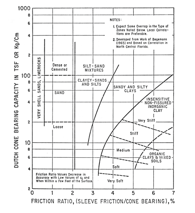
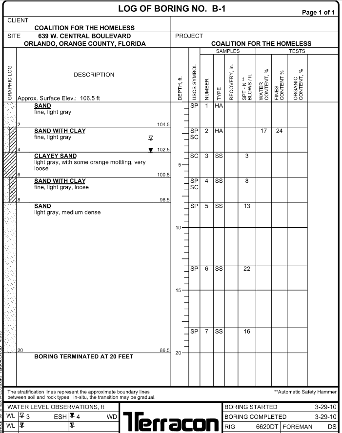
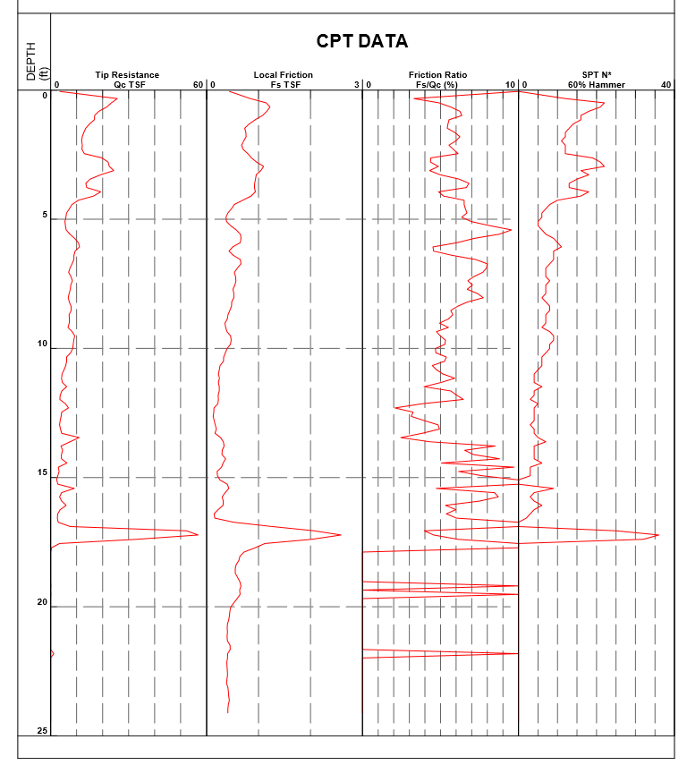
1. You are investigating a 250'x 250' 5 story building site, average soil conditions. Spread footings at 9 feet depth. Utility trenches will be a maximum of 18 feet deep. The boring logs provided by the Engineer show 25 borings. Boring Log B-1 by Terracon on the 2nd page of this homework is typical of the borings. Show all your calculations and graphics necessary to justify answers. a. Does the number of borings made during the design appear adequate? Explain. b. Does the depth of the borings appear adequate? c. What would you do if the number or depth of borings appears inadequate? d. Could dewatering of the site be necessary? Explain. 1000 8 6 NOTES: 1. Expect Some Overlap in the Type of Zones Noted Below. Local Correla- tions are preferable. 2. Developed from Work of Begemann (1965) and Based on Correlation in North Central Florida 2 Dense or Cemented SILT - SAND MIXTURES 100 CLAYEY-SANDS AND SILTS T VERY SHELL SANDS, LIMEROCKS 1 SANDY AND SILTY CLAYS SAND DUTCH CONE BEARING CAPACITY IN TSF OR Kg/cm INSENSITIVE NON-FISSURED INORGANIC CLAY ! 2 Very Stift Loose Still 10 Medium ORGANIC CLAYS & MIXED SOILS Soft Friction Ratio Values Decrease in Accuracy with Low Values of ac and When within a Few Feet of the Surface Very Soft 1 o 2 3 4 5 6 7 FRICTION RATIO, (SLEEVE FRICTION/CONE BEARING),% LOG OF BORING NO. B-1 Page 1 of 1 CLIENT COALITION FOR THE HOMELESS SITE 639 W. CENTRAL BOULEVARD PROJECT ORLANDO, ORANGE COUNTY, FLORIDA COALITION FOR THE HOMELESS SAMPLES TESTS DESCRIPTION GRAPHIC LOG DEPTH, ft. USCS SYMBOL NUMBER RECOVERY, in SPT-N BLOWS/ft WATER CONTENT, % CONTENT% FINES TYPE ORGANIC CONTENT, % Approx. Surface Elev.: 106.5 ft SAND fine, light gray 1 HA 104.5 17 24 SAND WITH CLAY fine, light gray SP 2 JHA SC 102.5 SC 3 SS 3 CLAYEY SAND light gray, with some orange mottling, very loose 5 100.5 4 SS 8 SAND WITH CLAY fine, light gray, loose SP SC 98.5 || SP 5 SS SAND light gray, medium dense 10 SP 6 SS 22 15 SPI 7 ss 16 20 86.5 20 BORING TERMINATED AT 20 FEET **Automatic Safety Hammer The stratification lines represent the approximate boundary lines between soil and rock types: In-situ, the transition may be gradual. WATER LEVEL OBSERVATIONS, ft WL 3 ESH 14 WD WL V 3-29-10 Terracon BORING STARTED BORING COMPLETED RIG 6620DT FOREMAN 3-29-10 DS CPT DATA DEPTH (ft) Tip Resistance Qc TSF Local Friction Fs TSF 600 Friction Ratio Fs/Qc (%) 0 30 SPT N* 60% Hammer 100 40 0 # RII ISI 5 DIT 10 * 15 HPI ||| 20 25 1. You are investigating a 250'x 250' 5 story building site, average soil conditions. Spread footings at 9 feet depth. Utility trenches will be a maximum of 18 feet deep. The boring logs provided by the Engineer show 25 borings. Boring Log B-1 by Terracon on the 2nd page of this homework is typical of the borings. Show all your calculations and graphics necessary to justify answers. a. Does the number of borings made during the design appear adequate? Explain. b. Does the depth of the borings appear adequate? c. What would you do if the number or depth of borings appears inadequate? d. Could dewatering of the site be necessary? Explain. 1000 8 6 NOTES: 1. Expect Some Overlap in the Type of Zones Noted Below. Local Correla- tions are preferable. 2. Developed from Work of Begemann (1965) and Based on Correlation in North Central Florida 2 Dense or Cemented SILT - SAND MIXTURES 100 CLAYEY-SANDS AND SILTS T VERY SHELL SANDS, LIMEROCKS 1 SANDY AND SILTY CLAYS SAND DUTCH CONE BEARING CAPACITY IN TSF OR Kg/cm INSENSITIVE NON-FISSURED INORGANIC CLAY ! 2 Very Stift Loose Still 10 Medium ORGANIC CLAYS & MIXED SOILS Soft Friction Ratio Values Decrease in Accuracy with Low Values of ac and When within a Few Feet of the Surface Very Soft 1 o 2 3 4 5 6 7 FRICTION RATIO, (SLEEVE FRICTION/CONE BEARING),% LOG OF BORING NO. B-1 Page 1 of 1 CLIENT COALITION FOR THE HOMELESS SITE 639 W. CENTRAL BOULEVARD PROJECT ORLANDO, ORANGE COUNTY, FLORIDA COALITION FOR THE HOMELESS SAMPLES TESTS DESCRIPTION GRAPHIC LOG DEPTH, ft. USCS SYMBOL NUMBER RECOVERY, in SPT-N BLOWS/ft WATER CONTENT, % CONTENT% FINES TYPE ORGANIC CONTENT, % Approx. Surface Elev.: 106.5 ft SAND fine, light gray 1 HA 104.5 17 24 SAND WITH CLAY fine, light gray SP 2 JHA SC 102.5 SC 3 SS 3 CLAYEY SAND light gray, with some orange mottling, very loose 5 100.5 4 SS 8 SAND WITH CLAY fine, light gray, loose SP SC 98.5 || SP 5 SS SAND light gray, medium dense 10 SP 6 SS 22 15 SPI 7 ss 16 20 86.5 20 BORING TERMINATED AT 20 FEET **Automatic Safety Hammer The stratification lines represent the approximate boundary lines between soil and rock types: In-situ, the transition may be gradual. WATER LEVEL OBSERVATIONS, ft WL 3 ESH 14 WD WL V 3-29-10 Terracon BORING STARTED BORING COMPLETED RIG 6620DT FOREMAN 3-29-10 DS CPT DATA DEPTH (ft) Tip Resistance Qc TSF Local Friction Fs TSF 600 Friction Ratio Fs/Qc (%) 0 30 SPT N* 60% Hammer 100 40 0 # RII ISI 5 DIT 10 * 15 HPI ||| 20 25