 undefined
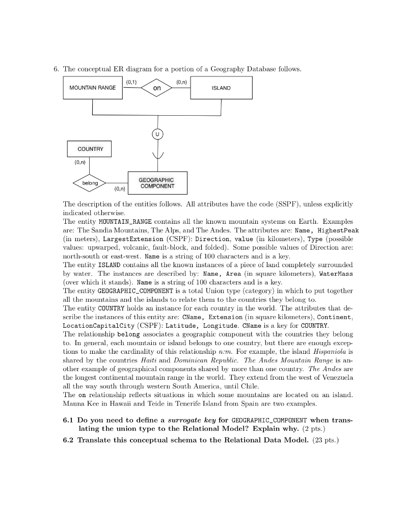
6. The conceptual ER diagram for a portion of a Geography Database follows. (0,1) (0.n) MOUNTAIN RANGE on ISLAND COUNTRY (0.n) ) belong GEOGRAPHIC COMPONENT (0.n) The description of the entities follows. All attributes have the code (SSPF), unless explicitly indicated otherwise. The entity MOUNTAIN_RANGE contains all the known mountain systems on Earth. Examples are: The Sandia Mountains, The Alps, and The Andes. The attributes are: Name, Highest Peak (in meters), Largest Extension (CSPF): Direction, value (in kilometers), Type (possible values: upwarped, volcanic, fault-block, and folded). Some possible values of Direction are: north-south or east-west. Name is a string of 100 characters and is a key. The entity ISLAND contains all the known instances of a piece of land completely surrounded by water. The instances are described by: Name, Area (in square kilometers), WaterMass (over which it stands). Name is a string of 100 characters and is a key. The entity GEOGRAPHIC_COMPONENT is a total Union type (category) in which to put together all the mountains and the islands to relate them to the countries they belong to. The entity COUNTRY holds an instance for each country in the world. The attributes that de- scribe the instances of this entity are: CName, Extension (in square kilometers), Continent, LocationCapitalCity (CSPF): Latitude, Longitude. CName is a key for COUNTRY. The relationship belong associates a geographic component with the countries they belong to. In general, each mountain or island belongs to one country, but there are enough excep- tions to make the cardinality of this relationship nim. For example, the island Hispaniola is shared by the countries Haiti and Dominican Republic. The Andes Mountain Range is an- other example of geographical components shared by more than one country. The Andes are the longest continental mountain range in the world. They extend from the west of Venezuela all the way south through western South America, until Chile. The on relationship reflects situations in which some mountains are located on an island. Mauna Kee in Hawaii and Teide in Tenerife Island from Spain are two examples. 6.1 Do you need to define a surrogate key for GEOGRAPHIC_COMPONENT when trans- lating the union type to the Relational Model? Explain why. (2 pts.) 6.2 Translate this conceptual schema to the Relational Data Model. (23 pts.) 6. The conceptual ER diagram for a portion of a Geography Database follows. (0,1) (0.n) MOUNTAIN RANGE on ISLAND COUNTRY (0.n) ) belong GEOGRAPHIC COMPONENT (0.n) The description of the entities follows. All attributes have the code (SSPF), unless explicitly indicated otherwise. The entity MOUNTAIN_RANGE contains all the known mountain systems on Earth. Examples are: The Sandia Mountains, The Alps, and The Andes. The attributes are: Name, Highest Peak (in meters), Largest Extension (CSPF): Direction, value (in kilometers), Type (possible values: upwarped, volcanic, fault-block, and folded). Some possible values of Direction are: north-south or east-west. Name is a string of 100 characters and is a key. The entity ISLAND contains all the known instances of a piece of land completely surrounded by water. The instances are described by: Name, Area (in square kilometers), WaterMass (over which it stands). Name is a string of 100 characters and is a key. The entity GEOGRAPHIC_COMPONENT is a total Union type (category) in which to put together all the mountains and the islands to relate them to the countries they belong to. The entity COUNTRY holds an instance for each country in the world. The attributes that de- scribe the instances of this entity are: CName, Extension (in square kilometers), Continent, LocationCapitalCity (CSPF): Latitude, Longitude. CName is a key for COUNTRY. The relationship belong associates a geographic component with the countries they belong to. In general, each mountain or island belongs to one country, but there are enough excep- tions to make the cardinality of this relationship nim. For example, the island Hispaniola is shared by the countries Haiti and Dominican Republic. The Andes Mountain Range is an- other example of geographical components shared by more than one country. The Andes are the longest continental mountain range in the world. They extend from the west of Venezuela all the way south through western South America, until Chile. The on relationship reflects situations in which some mountains are located on an island. Mauna Kee in Hawaii and Teide in Tenerife Island from Spain are two examples. 6.1 Do you need to define a surrogate key for GEOGRAPHIC_COMPONENT when trans- lating the union type to the Relational Model? Explain why. (2 pts.) 6.2 Translate this conceptual schema to the Relational Data Model. (23 pts.)