

Question
You have been asked by a mining company to fly an aerial survey for them.The area to be imaged is a 30 km (E-W) by
You have been asked by a mining company to fly an aerial survey for them.The area to be imaged is a 30 km (E-W) by 40 km (N-S) rectangle. The mining company would like the aerial digital images to be captured at 10 cm ground sample distance (GSD) with a Vexcel Ultracam X digital mapping camera [sensor size: 6 cm (H) x 10 cm (W), 9400 (H) x 14400 (W) pixels]. The focal length of the camera is 104 mm. The aerial images should have an average forward overlap of 60% and an average sidelap of 30%.
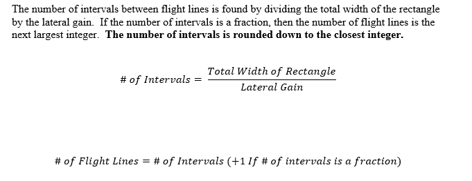
The number of required flight lines is a product of the required amount of sidelap, the lateral distance covered by a single image (swath width) and the total width of the rectangular area to be imaged. Assuming an average sidelap of 30% (or 0.3), the lateral gain from one line to another is 70% (or 0.7) of the swath width of an image.

Step by Step Solution
There are 3 Steps involved in it
Step: 1

Get Instant Access to Expert-Tailored Solutions
See step-by-step solutions with expert insights and AI powered tools for academic success
Step: 2

Step: 3
Ace Your Homework with AI
Get the answers you need in no time with our AI-driven, step-by-step assistance
Get Started
Elementary Statisitcs
Authors: Barry Monk
2nd edition
1259345297, 978-0077836351, 77836359, 978-1259295911, 1259295915, 978-1259292484, 1259292487, 978-1259345296