All Matches
Solution Library
Expert Answer
Textbooks
Search Textbook questions, tutors and Books
Oops, something went wrong!
Change your search query and then try again
Toggle navigation
FREE Trial
S
Books
FREE
Tutors
Study Help
Expert Questions
Accounting
General Management
Mathematics
Finance
Organizational Behaviour
Law
Physics
Operating System
Management Leadership
Sociology
Programming
Marketing
Database
Computer Network
Economics
Textbooks Solutions
Accounting
Managerial Accounting
Management Leadership
Cost Accounting
Statistics
Business Law
Corporate Finance
Finance
Economics
Auditing
Hire a Tutor
AI Study Help
New
Search
Search
Sign In
Register
study help
sciences
introduction to geographic information
Questions and Answers of
Introduction To Geographic Information
Among the graphics presented in Section 10.1.2, which are designed for multivariate (i.e., two or more variables) visualization?
Suppose you have downloaded a GIS data set. The feature attribute table has a field that contains values such as 12, 13, and so on. How can you find out in ArcGIS if these values represent numbers or
Suppose you have downloaded a GIS data set.The data set has the length measure in meters instead of feet. Describe the steps you will follow to add a length measure in feet to the data set.
Provide a real-world example (other than those of Chapter 8) of a one-to-many relationship.
Define map algebra.
Cost distance measure operations are based on the node-link cell representation. Explain the representation by using a diagram.
Define the RMS error in geometric transformation.
Refer to Table 10.1, and fill in the blank for each of the following query operations: [Create a new selection] "cost"> 8 of 10 records selected [Add to current selection] "soiltype" = 'N3' OR
Describe the two common types of data for terrain mapping and analysis.
Go to the USGS National Map website (https://viewer.nationalmap.gov/basic/) and read the information about different types of elevation products available for download.
Define geospatial data.
Describe an example of GIS application from your discipline.
Go to the USGS National Map website (http://nationalmap.gov/viewer.html) and see what kinds of geospatial data are available for download.
Go to the National Institute of Justice website (http://www.ojp.usdoj.gov/nij/maps/) and read how GIS is used for crime analysis.
Location-based services are probably the most commercialized GIS-related field. Search for “location-based service” on Wikipedia (http://www.wikipedia.org/) and read what has been posted on the
What types of software and hardware are you currently using for GIS classes and projects?
Try the map locators offered by Microsoft Virtual Earth, Yahoo! Maps, and Google Maps, respectively. State the major differences among these three systems.
Define geometries and attributes as the two components of GIS data.
Explain the difference between vector data and raster data.
Explain the difference between the georelational data model and the object-based data model.
Provide an example of mashup mapping.
Why is “volunteered geographic information” useful for disaster management?
The following link, http://www.openstreetmap.org/#map=12/52.1977/0.1507, shows a map of Cambridge, England, based on OpenStreetMap data. Use the map to compare the quality of OpenStreetMap data with
Suppose you are required to do a GIS project for a class. What types of activities or operations do you have to perform to complete the project?
Name two examples of vector data analysis.
Name two examples of raster data analysis.
Describe an example from your discipline in which a GIS can provide useful tools for building a model.
Explain the difference between NAD27 and NAD83.
What is WGS84?
Pick up a USGS quadrangle map of your area. Examine the information on the map margin. If the datum is changed from NAD27 to NAD83, what is the expected horizontal shift?
Go to the NGS-CORS website (http://www.ngs .noaa.gov/CORS/). How many continuously operating reference stations do you have in your state? Use the links at the website to learn more about CORS.
Explain the importance of map projection.
Describe the four types of map projections by the preserved property.
Describe the three types of map projections by the projection or developable surface.
Explain the difference between the standard line and the central line.
How is the scale factor related to the principal scale?
Name two commonly used projected coordinate systems that are based on the transverse Mercator projection.
Google the GIS data clearinghouse for your state. Go to the clearinghouse website.Does the website use a common coordinate system for the statewide data sets? If so, what is the coordinate system?
What is Web Mercator?
Explain how a UTM zone is defined in terms of its central meridian, standard meridian, and scale factor.
Which UTM zone are you in? Where is the central meridian of the UTM zone?
How many SPC zones does your state have?What map projections are the SPC zones based on?
Describe how on-the-fly projection works.
Google the GIS data clearinghouse for your state. Go to the clearinghouse website. What data format(s) does the website use for delivering vector data?
Name the three types of simple features used in GIS and their geometric properties.
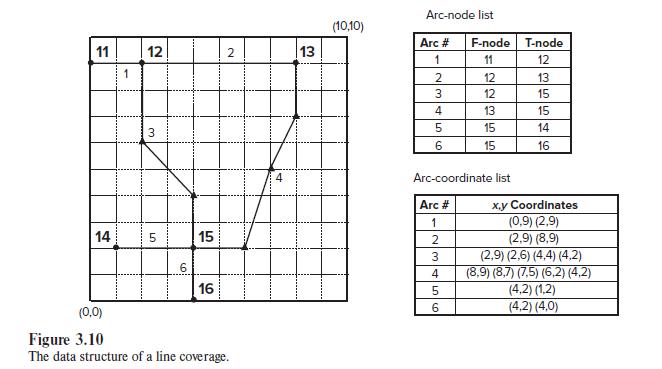
How many arcs connect at node 12 in Figure 3.10? 11 12 14 1 3 5 6 15 16 2 (0,0) Figure 3.10 The data structure of a line coverage. 13 (10,10) Arc-node list Arc #
Draw a stream coverage and show how the topological relationships of connectivity and contiguity can be applied to the coverage.
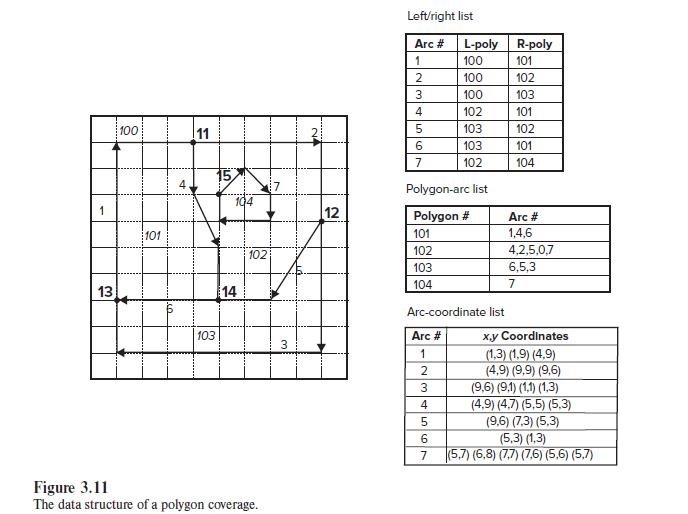
Suppose an arc (arc 8) is added to Figure 3.11 from node 13 to node 11. Write the polygon/arc list for the new polygons and the left/right list for arc 8. 1 13 100 101 4 11 15 103 104 14 102 Figure
Explain the importance of topology in GIS.
What are the main advantages of using shapefiles?
Explain the difference between the georelational data model and the object-based data model.
Describe the difference between the geodatabase and the coverage in terms of the geometric representation of spatial features.
Explain the relationship between the geodatabase, feature dataset, and feature class.
Feature dataset is useful for data management.Can you think of an example in which you would want to organize data by feature dataset?
Explain the difference between a personal geodatabase and a file geodatabase.
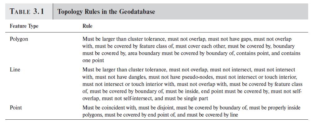
Table 3.1 shows “must not overlap” as a topology rule for polygon features. Provide an example from your discipline that can benefit from enforcement of this topology rule. TABLE 3.1 Feature
What is ArcObjects?
Provide an example of an object from your discipline and suggest the kinds of properties and methods that the object can have.
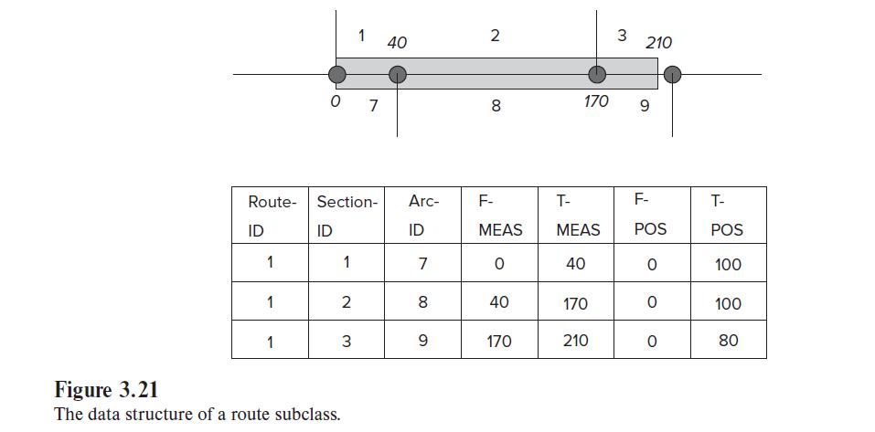
Compare Figure 3.21 with Figure 3.23, and explain the difference between the geodatabase and the coverage in handling the route data structure. Route ID 1 1 1 07 Section- ID 1 2 1 3 Figure 3.21 The
“Must not intersect” is a topology rule for line features. Provide an example from your discipline that can benefit from enforcing this topology rule.
The text covers several advantages of adopting the geodatabase. Can you think of an example in which you would prefer the geodatabase to the coverage for a GIS project?
Draw a small TIN to illustrate that it is a composite of simple features.
What are the basic elements of the raster data model?
Explain the advantages and disadvantages of the raster data model versus the vector data model.
Name two examples each for integer rasters and floating-point rasters.
Explain the relationship between cell size, raster data resolution, and raster representation of spatial features.
You are given the following information on a 30-meter DEM:• UTM coordinates in meters at the lower-left corner: 560635, 4816399 • UTM coordinates in meters at the upperright corner: 570595,
Explain the difference between passive and active satellite systems.
Go to the DigitalGlobe website (http://www.satimagingcorp.com/), and take a look at their very high resolution sample imagery.
What is a digital elevation model?
Describe three new data sources for producing DEMs.
Go to the USGS National Map website (http://nationalmap.gov/3dep_prodserv.html#) and check the kinds of DEM data that are available from the USGS.
Google the GIS data clearinghouse for your state. Go to the clearinghouse website. Does the website offer USGS DEMs, DRGs, and DOQs online? Does the website offer both 30-meter and 10-meter USGS DEMs?
Use a diagram to explain how the run-length encoding method works.
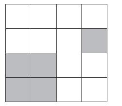
Refer to the following figure, draw a quadtree, and code the spatial index of the shaded (spatial) feature.
Explain the difference between lossless and lossy compression methods.
What is vectorization?
Use an example from your discipline and explain the usefulness of integrating vector and raster data.
What is a geoportal?
Name the two geoportals maintained by the USGS.
What kinds of data can you download from the USGS Earth Explorer?
List the spatial resolutions of DEMs available from the National Map.
What kinds of data are contained in the USGS DLG files?
Name NASA’s two geoportals.
What kinds of data and services can you get from OpenTopography funded by the National Science Foundation?
What is SSURGO?
Suppose you want to make a map showing the rate of population change between 2000 and 2010 by county in your state. Describe (1) the kinds of digital data you will need for the mapping project, and
Google the GIS data clearinghouse for your state. Go to the clearinghouse website. Select the metadata of a data set and go over the information in each category.
Define “neutral format” for data conversion.
What kinds of data are contained in the TIGER/Line files?
Explain how GPS data can be converted into GIS layers.
Explain how differential correction works.
What types of GPS data errors can be corrected by differential correction?
A reference geoid is needed for deriving heights of GPS data. What is a reference geoid?
What kinds of data must exist in a text file so that the text file can be converted to a shapefile?
What is COGO?
Suppose you are asked to convert a paper map to a digital data set. What methods can you use for the task? What are the advantages and disadvantages of each method?
The scanning method for digitizing involves both rasterization and vectorization. Why?
Describe the difference between on-screen digitizing and tablet digitizing.
Explain map-to-map transformation.
Showing 1 - 100
of 312
1
2
3
4