

Question: Draw structure contours on Fig. G-3. Use a 400-ft contour interval (including 0, 400, 800, 1200, etc.). Assume that, unlike the example in Fig. 2.8,
Draw structure contours on Fig. G-3. Use a 400-ft contour interval (including 0, 400, 800, 1200, etc.). Assume that, unlike the example in Fig. 2.8, this surface is not broken by faults, so your structure contours should be continuous.
If you do not know how to begin, here is a suggestion. Find a point, such as the 799-ft point, with an elevation that is close to the elevation of one of the contour lines. You know that the 800-ft contour passes very close to this point, but where does it go from there? To the east and northeast are two points with elevations of 1013 ft and 516 ft; 800 lies between these two elevations, so the 800-ft contour must pass between these two points, closer to the 1013-ft point than to the 516-ft point. Once you have a few lines drawn, the rest will fall into place. Your structure contours should be smooth, subparallel lines. Use a pencil; this is a trial-and-error operation. Be sure to label the elevation of each structure contour as you draw it.
When you are finished you should be able to recognize some folds. Using the symbols in Appendix F, draw appropriate fold symbols on your structure-contour map. Also draw a few strike-and-dip symbols on the map, but without specifying the amount of dip.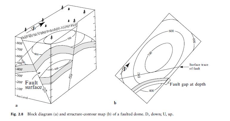
Fig. G-3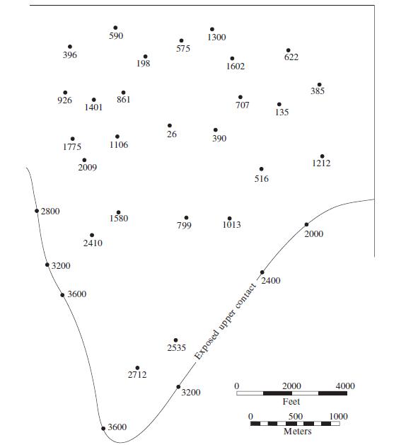
---800 700 600 S00 -400 / -300 200 Fault surface) -100' Sea Level- a 400 -700 b DU 400 600 500 Fig. 2.8 Block diagram (a) and structure-contour map (b) of a faulted dome. D, down; U, up. Surface trace of fault Fault gap at depth
Step by Step Solution
3.43 Rating (162 Votes )
There are 3 Steps involved in it

Get step-by-step solutions from verified subject matter experts