Question
Along the Nmes aqueduct, a large box culvert is located at Vallon No. 6, located 17 km downstream of Pont du Gard. The culvert was
Along the Nmes aqueduct, a large box culvert is located at Vallon No. 6, located 17 km downstream of Pont du Gard. The culvert was designed to allow stormwater passage beneath the aqueduct in a small valley, locally called combe. Note that catchment area is very small: i.e. 0.028 km2. The culvert is a multi-cell structure equipped with three rectangular cells. The cells are 0.5, 0.8 and 0.6 m wide. Each cell has an internal height of 0.65 m. The barrel length is 3.7 m and the invert slope is about 0.05. (The invert is worked bedrock: ks 10 mm.) The upstream end of each dividing wall is cut in a chamfer to form cut-waters. Upstream and downstream of the culvert, the natural bed slope is steep (i.e. So 0.16) and consists of gravels (ks 50 mm). The valley is narrow and may be approximated as a 3.2 m wide rectangular cross-section. For a catchment runoff of 1.5 m3 /s, calculate the normal depth in the valley. For the same runoff, calculate the change in upstream water level caused by the presence of the culvert. Did the culvert operate with inlet control or outlet control? Using the software Hydroculv, calculate the change in upstream water level caused by the presence of the culvert for a runoff of 1.5 m3 /s. Compute the flow velocity in the barrel.
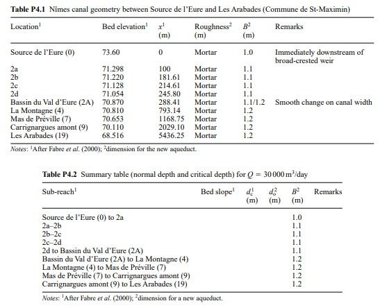
Table P4.1 Nimes canal geometry between Source de l'Eure and Les Arabades (Commune de St-Maximin) Location Bed elevation! Roughness B Remarks (m) (m) (m) Source de l'Eure (0) 73.60 0 Mortar 1.0 Immediately downstream of broad-crested weir 2a 71.298 100 Mortar 1.1 2b 71.220 181.61 Mortar 1.1 2c 71.128 214.61 Mortar 1.1 2d 71.054 245.80 Mortar 1.1 Bassin du Val d'Eure (2A) 70.870 288.41 Mortar 1.1/1.2 La Montagne (4) Smooth change on canal width 70.810 793.14 Mortar 1.2 Mas de Prville (7) 70.653 1168.75 Mortar 1.2 Carrignargues amont (9) 70.110 2029.10 Mortar 1.2 Les Arabades (19) 68.516 5436.25 Mortar 1.2 Notes: "After Fabre et al. (2000): "dimension for the new aqueduct. Remarks Table P4.2 Summary table (normal depth and critical depth) for Q = 30000 m/day Sub-reach' Bed slope! d! (m) (m) (m) Source de l'Eure (0) to 2a 2a-2b 26-2c 2c-2d 2d to Bassin du Val d'Eure (2A) Bassin du Val d'Eure (2A) to La Montagne (4) 1.2 La Montagne (4) to Mas de Prville (7) 1.2 Mas de Prville (7) to Carrignargues amont (9) 1.2 Carrignargues amont (9) to Les Arabades (19) Notes: "After Fabre et al. (2000); "dimension for a new aqueduct. 1.0 1.1 1.1 1.1 1.1 !! 1.2 Table P4.1 Nimes canal geometry between Source de l'Eure and Les Arabades (Commune de St-Maximin) Location Bed elevation! Roughness B Remarks (m) (m) (m) Source de l'Eure (0) 73.60 0 Mortar 1.0 Immediately downstream of broad-crested weir 2a 71.298 100 Mortar 1.1 2b 71.220 181.61 Mortar 1.1 2c 71.128 214.61 Mortar 1.1 2d 71.054 245.80 Mortar 1.1 Bassin du Val d'Eure (2A) 70.870 288.41 Mortar 1.1/1.2 La Montagne (4) Smooth change on canal width 70.810 793.14 Mortar 1.2 Mas de Prville (7) 70.653 1168.75 Mortar 1.2 Carrignargues amont (9) 70.110 2029.10 Mortar 1.2 Les Arabades (19) 68.516 5436.25 Mortar 1.2 Notes: "After Fabre et al. (2000): "dimension for the new aqueduct. Remarks Table P4.2 Summary table (normal depth and critical depth) for Q = 30000 m/day Sub-reach' Bed slope! d! (m) (m) (m) Source de l'Eure (0) to 2a 2a-2b 26-2c 2c-2d 2d to Bassin du Val d'Eure (2A) Bassin du Val d'Eure (2A) to La Montagne (4) 1.2 La Montagne (4) to Mas de Prville (7) 1.2 Mas de Prville (7) to Carrignargues amont (9) 1.2 Carrignargues amont (9) to Les Arabades (19) Notes: "After Fabre et al. (2000); "dimension for a new aqueduct. 1.0 1.1 1.1 1.1 1.1 !! 1.2Step by Step Solution
There are 3 Steps involved in it
Step: 1
Get Instant Access to Expert-Tailored Solutions
See step-by-step solutions with expert insights and AI powered tools for academic success
Step: 2
Step: 3
Ace Your Homework with AI
Get the answers you need in no time with our AI-driven, step-by-step assistance
Get Started