

Question: < Exercise 21 Problems-Part I The following questions are based on Figures 21-10, 21-20, and 21-30, radar images of Louisiana from the Fort Polk
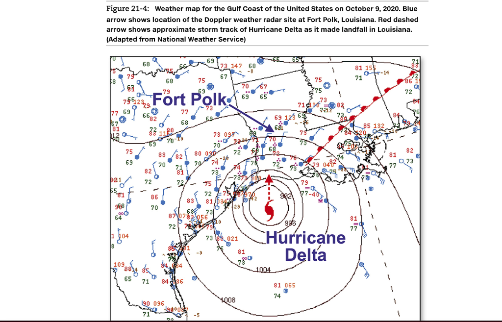
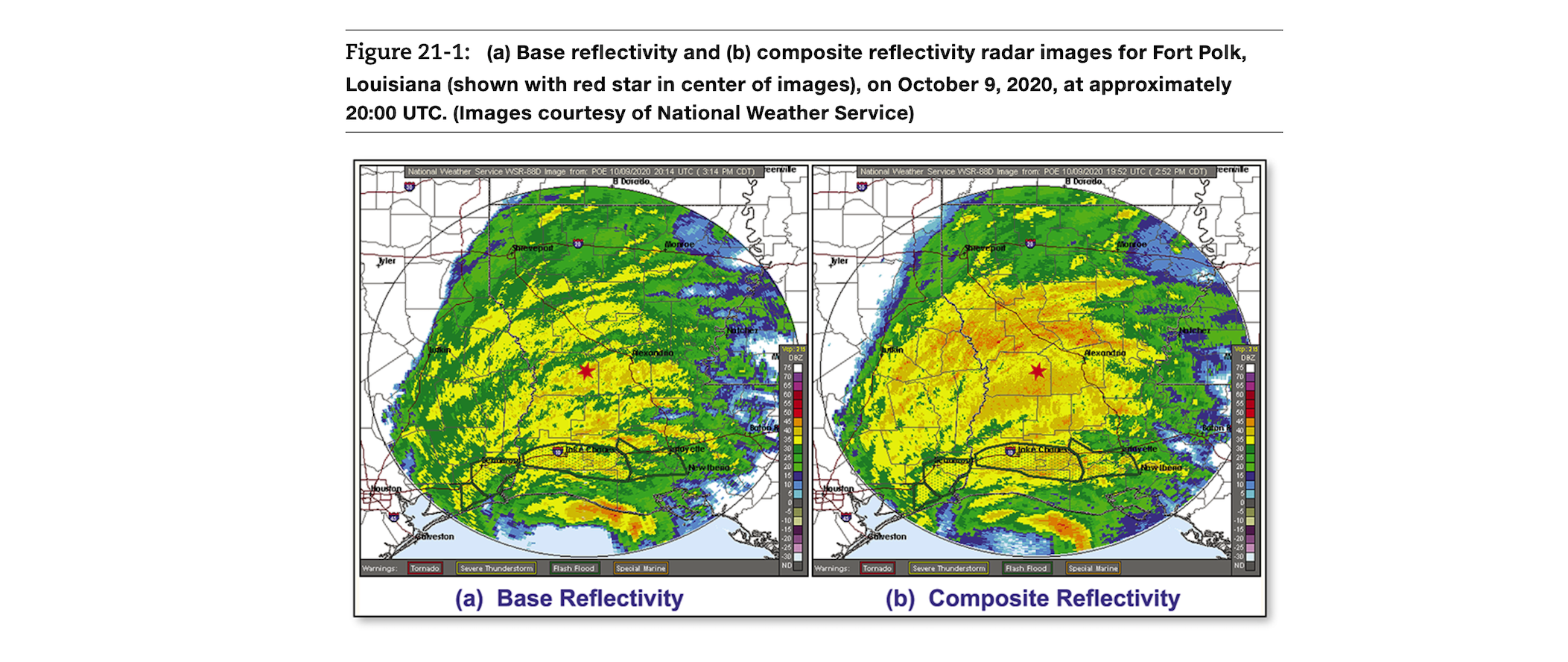
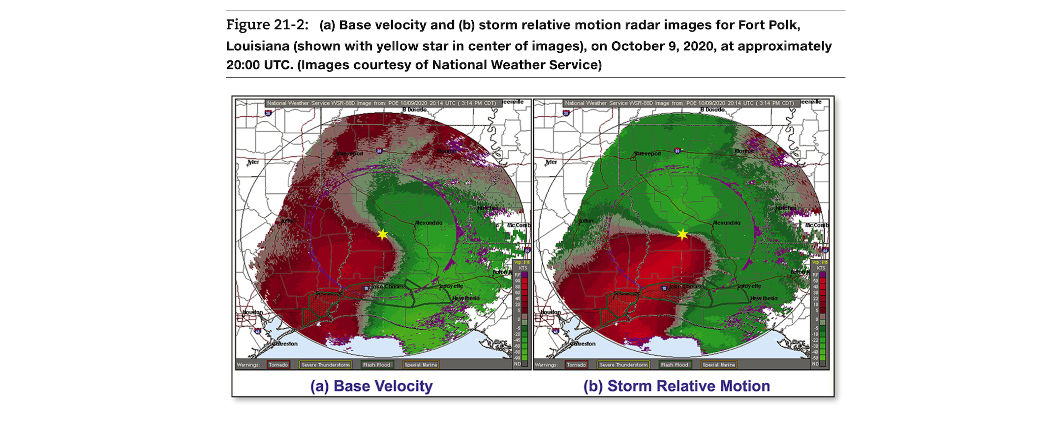
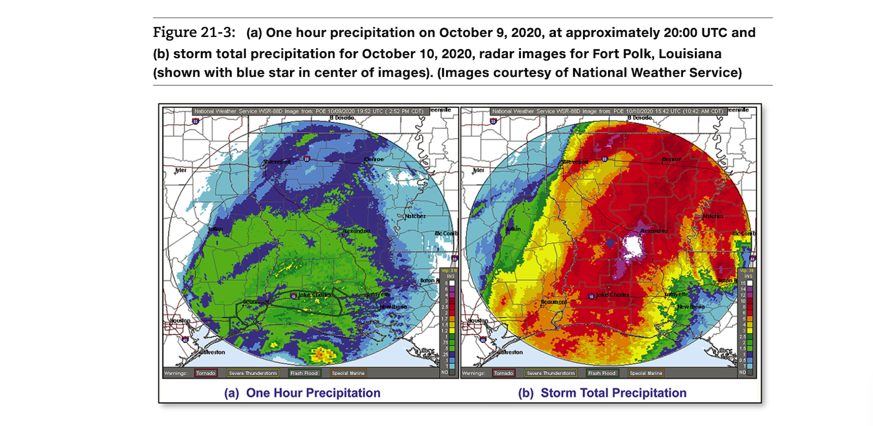
< Exercise 21 Problems-Part I The following questions are based on Figures 21-10, 21-20, and 21-30, radar images of Louisiana from the Fort Polk Doppler radar site taken on October 9, 2020, at about 20:00 UTC. At the time of these radar images, Hurricane Delta was moving toward landfall in southern Louisiana near the city of Lake Charles, south of the radar site. Figure 21-40 is a weather map showing the location of the Fort Polk radar site and the general storm track of Hurricane Delta as it approached shore. Figure 21-4: Weather map for the Gulf Coast of the United States on October 9, 2020. Blue arrow shows location of the Doppler weather radar site at Fort Polk, Louisiana. Red dashed arrow shows approximate storm track of Hurricane Delta as it made landfall in Louisiana. (Adapted from National Weather Service) 58 77 69 0 81 001 68 67 786239 f 75 69 Q 6682 33 82 72 75 79 69 Fort Polk 73 69 68 1180 83 70 77 68 70-13 69 80 70 82 71 81 727 75 73 147 68 67 73 097 O 70 74 70 67 69 5 65 69 12 69 75 75 71138 79 73 7212 0482 81 155 0-14 71 85 132 81 77 86 72 82 Q73 Figure 21-4: Weather map for the Gulf Coast of the United States on October 9, 2020. Blue arrow shows location of the Doppler weather radar site at Fort Polk, Louisiana. Red dashed arrow shows approximate storm track of Hurricane Delta as it made landfall in Louisiana. (Adapted from National Weather Service) $8 . 77 69 7562379 75 69 3-21 $5gy 968 640 109 68 6682 Z3 0 1180 69 65 82 72 Fort Polk 86 70 68 70 190 096 77 72/ 8486 75 80 73 147 67 74-36 81 73 097 70* 20.0 2224 72** 73 88021 1008 70 68 69 81 65 69 A 6& 1004 [ 2.0 65 996 79 =Q 902 77-40 75 81 065 74 Hurricane Delta 1 81 155 71 81 77 0-14 1. Why does the composite reflectively image (Figure 21-1b) show a wider area of precipitation than the base reflectivity image (Figure 21-1a)? 2. Using the base velocity image (Figure 21-2a), estimate the dominant wind direction coming toward the Fort Polk radar site (shown with a yellow star): 3. a. Using the storm relative motion image (Figure 21-2b), estimate the dominant wind direction at the Fort Polk radar site if the storm was not moving: b. What explains this general direction of wind on this day? (Hint: Look at the location of Hurricane Delta relative to the radar site.) 4. What explains the difference in wind direction shown in the base velocity image (Figure 21-2a) and the storm relative motion image (Figure 21-2b)? 5. At the time of the one-hour precipitation radar image (Figure 21-3a), was rain falling more heavily to the north or the south of the radar site (shown with a blue star)? 6. At the time of the one-hour precipitation image (Figure 21-3a), about how much rain was falling per hour in the area around the radar site? 21: Doppler Weather Radar a. Using the storm relative motion image (Figure 21-2b), estimate the dominant wind direction at the Fort Polk radar site if the storm was not moving: b. What explains this general direction of wind on this day? (Hint: Look at the location of Hurricane Delta relative to the radar site.) 4. What explains the difference in wind direction shown in the base velocity image (Figure 21-2a) and the storm relative motion image (Figure 21-2b)? 5. At the time of the one-hour precipitation radar image (Figure 21-3a), was rain falling more heavily to the north or the south of the radar site (shown with a blue star)? 6. At the time of the one-hour precipitation image (Figure 21-3a), about how much rain was falling per hour in the area around the radar site? Name 7. Use the storm total precipitation image (Figure 21-3b) to estimate the total amount of rain that fell at the radar site as a result of Hurricane Delta passing through this area: Section Figure 21-1: (a) Base reflectivity and (b) composite reflectivity radar images for Fort Polk, Louisiana (shown with red star in center of images), on October 9, 2020, at approximately 20:00 UTC. (Images courtesy of National Weather Service) Jyler Warnings: National Weather Service WSR-880 Image from: POE 10/09/2020 20:14 UTC (3:14 PM CDT) teenzile 8 Dorado reston Tornado Severe Thunderstorm Flash Flood Special Marine (a) Base Reflectivity New Ibero Jyler National Weather Service WSR-880 Image from: POE 10/09/2020 19:52 UTC (2:52 PM CDT) teenfile 8 Dorado, reston Warnings: Tornado Joke Choo Severe Thunderstorm Flash Flood Aexanino Special Marine (b) Composite Reflectivity 2333397888222008044485 Figure 21-2: (a) Base velocity and (b) storm relative motion radar images for Fort Polk, Louisiana (shown with yellow star in center of images), on October 9, 2020, at approximately 20:00 UTC. (Images courtesy of National Weather Service) Jyler National Weather Service WSR-880 Image from: POE 10/09/2020 20:14 UTC (3:14 PM CDT) Jeenvile 8 Dorado, 30 olveston Warnings: Tornado Severe Thunderstorm Flash Flood Alexandria Special Marine (a) Base Velocity tay ette New beno McCo Jyler Warnings: National Weather Service WSR-880 Image from: POE 10/09/2020 20:14 UTC (3:14 PM CDT) teeninle 30 8 Dorado aveston Tornado Shreveport Severe Thunderstorm Flash Flood Moringe Alexandria Special Marine fayette New Iberia (b) Storm Relative Motion Mc Con b KTS Figure 21-3: (a) One hour precipitation on October 9, 2020, at approximately 20:00 UTC and (b) storm total precipitation for October 10, 2020, radar images for Fort Polk, Louisiana (shown with blue star in center of images). (Images courtesy of National Weather Service) Jyler National Weather Service WSR-880 Image from: POE 10/09/2020 19.52 UTC (2.52 PM CDT) teenile 8 Dorado, reston Warnings: Tornado Joke cha Severe Thunderstorm Flash Flood Corroe Special Marine (a) One Hour Precipitation Natchez Baton Mc Comb Jyler Warnings: National Weather Service WSR-880 Image from: POE 10/10/2020 15:42 UTC (10:42 AM CDT) eenzile 8 Dorado 30 veston Tornado Beaumont Severe Thunderstorm Lake Charles Flash Flood Monroe Alexandri Special Marine Natchez ayette New Ibeno (b) Storm Total Precipitation
Step by Step Solution
3.50 Rating (160 Votes )
There are 3 Steps involved in it

Get step-by-step solutions from verified subject matter experts