Question
I have a txt file from which I need to draw data and use it to plot the path and a bar graph. I am
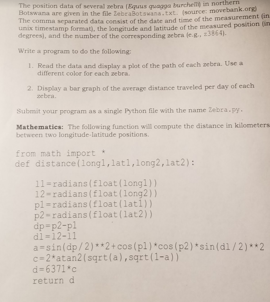
I have a txt file from which I need to draw data and use it to plot the path and a bar graph. I am having trouble designing the dictionary and lists for containing the information. Also could you suggest how I would plot them using the dictionaries. I will attach my code, the txt file, and assignment help sheet.
https://www.dropbox.com/s/yb67xy52rsuy2gy/ZebraBotswana.txt?dl=0
import pylab
from math import *
def distance(lon1, lat1, long2, lat2):
l1 = radians(float(long1))
l2 = radians(float(lat1))
p1 = radians(float(lat1))
p2 = radians(float(lat2))
dp = p2 -p1
d1 = l2 - l1
a = sin(dp/2)**2 + cos(p1)*cos(p2)*sin(d1/2)**2
c = atan2(sqrt*a, sqrt*1-a)
d = 6371 * c
return d
def Getltlg():
zebraltdict = {}
zebralgdict = {}
infile = open("ZebraBotswana.txt", "r")
readlines = infile.readlines()
Types = [line.split(',') for line in readlines]
if tuple(Types[3]) not in zebraltdict:
zebraltdict.setdefault(tuple(Types[3]), [])
if tuple(Types[3]) not in zebralgdict:
zebralgdict.setdefault(tuple(Types[3]), [])
for keys in zebraltdict.keys():
ltd = [Type[1] for Type in Types if Types[3] == keys]
zebraltdict[keys].append(ltd)
for keys in zebralgdict.keys():
lat = [Type[2] for Type in Types if Types[3] == keys]
zebralgdict[keys].append(lat)
infile.close()

The position data of several zebra (Equus quagga burchell) in northern Botswana are given in the file ZebraBotswana.txt. (source: movebank.org) The comma unix timestam degrees), and the number of the corresponding zebra (e.g., 23864). separated data consist of the date and time of the measurement (in p format), the longitude and latitude of the measured position (in Write a program to do the following: 1. Read the data and display a plot of the path of each zebra. Use a different color for each zebra. 2. Display a bar graph of the average distance traveled per day of each Submit your program as a single Python file with the name Zebra. py Mathematics: The following function will compute the distance in kilometers zebra. between two longitude-latitude positions. from math import * def distance(long1,latl,long2,lat2): 11-radians (float (lon 12-radians(float(long2)) pl-radians(float(latl)) p2-radians(float(lat2)) dp-p2-pl dl-12-11 a=sin(dp / 2 ) * * 2 + cos (p1 ) *cos (p2)*sin(a1 /2 ) * * 2 c-2*atan2 (sqrt(a),sqrt (1-a)) d-6371*c return d g1))
Step by Step Solution
There are 3 Steps involved in it
Step: 1

Get Instant Access to Expert-Tailored Solutions
See step-by-step solutions with expert insights and AI powered tools for academic success
Step: 2

Step: 3

Ace Your Homework with AI
Get the answers you need in no time with our AI-driven, step-by-step assistance
Get Started


