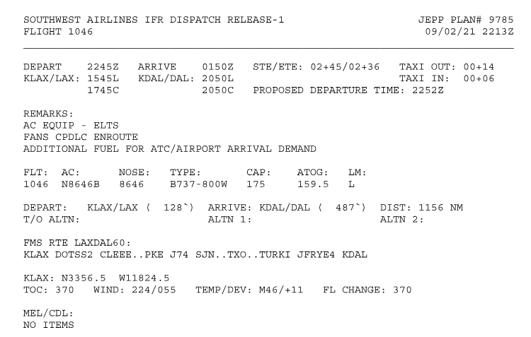
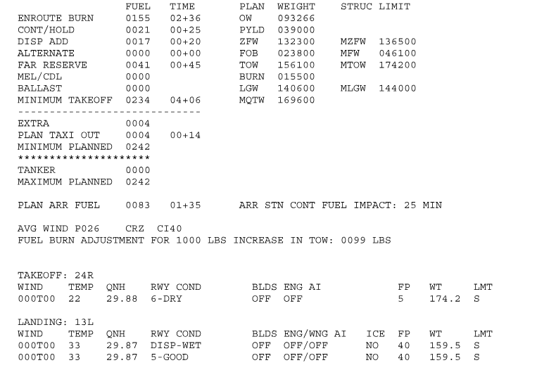
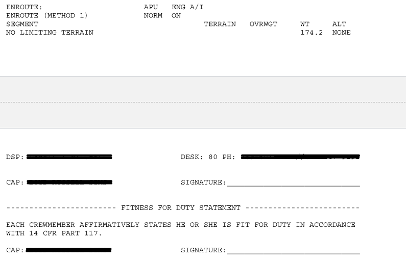
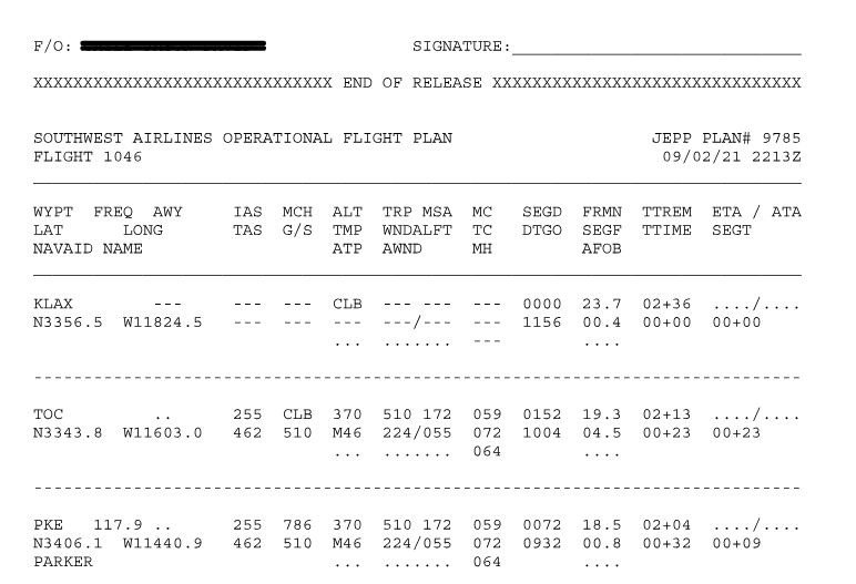
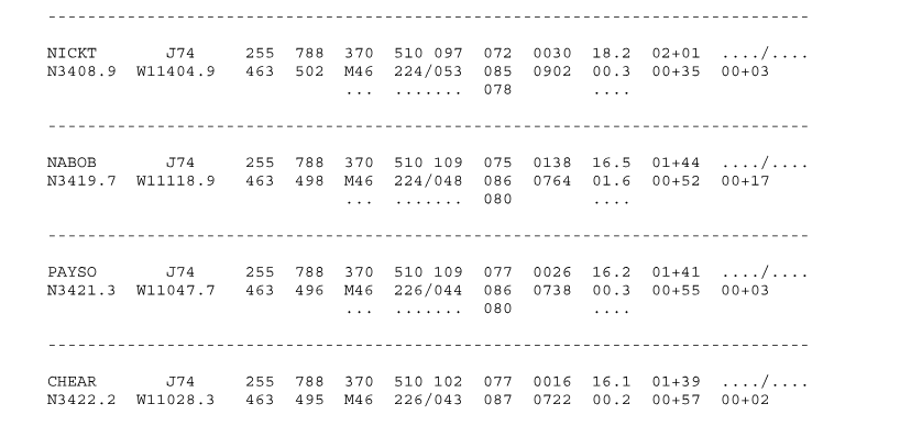
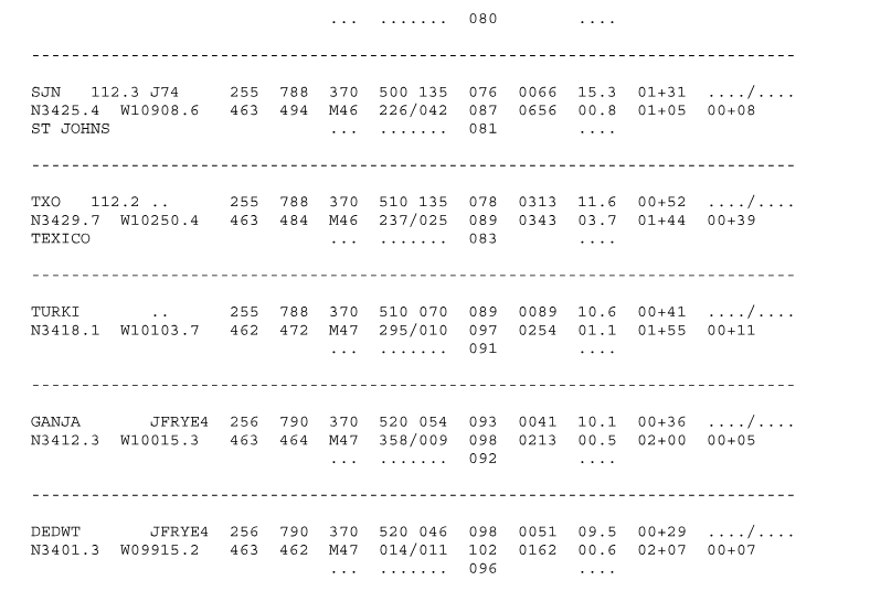
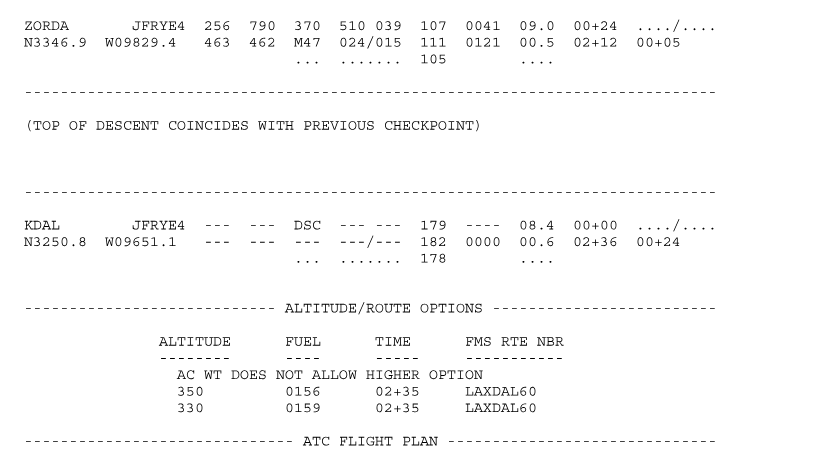
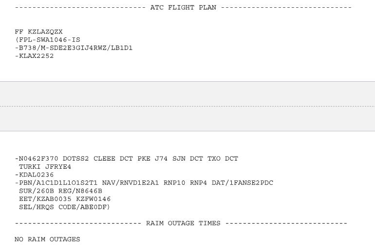
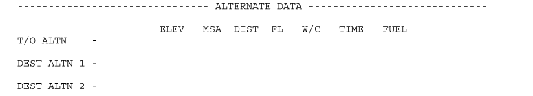
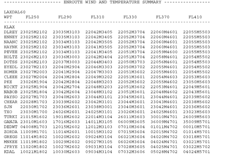
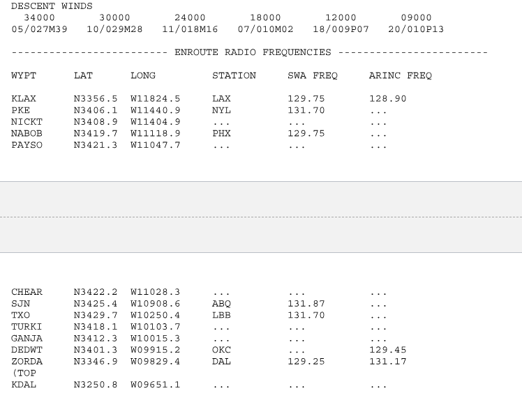
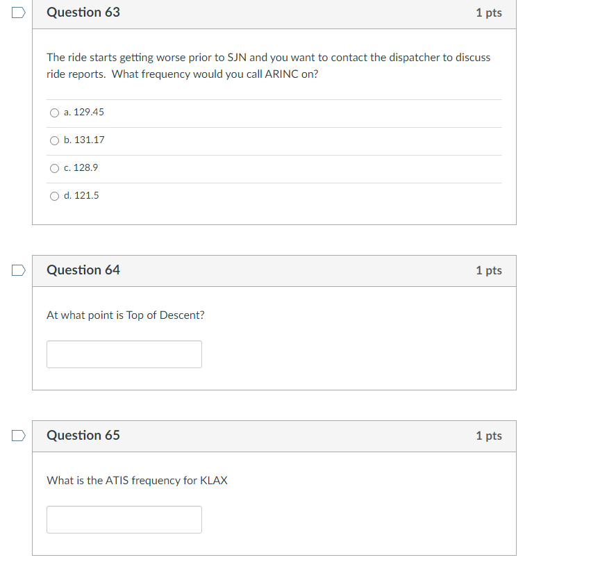
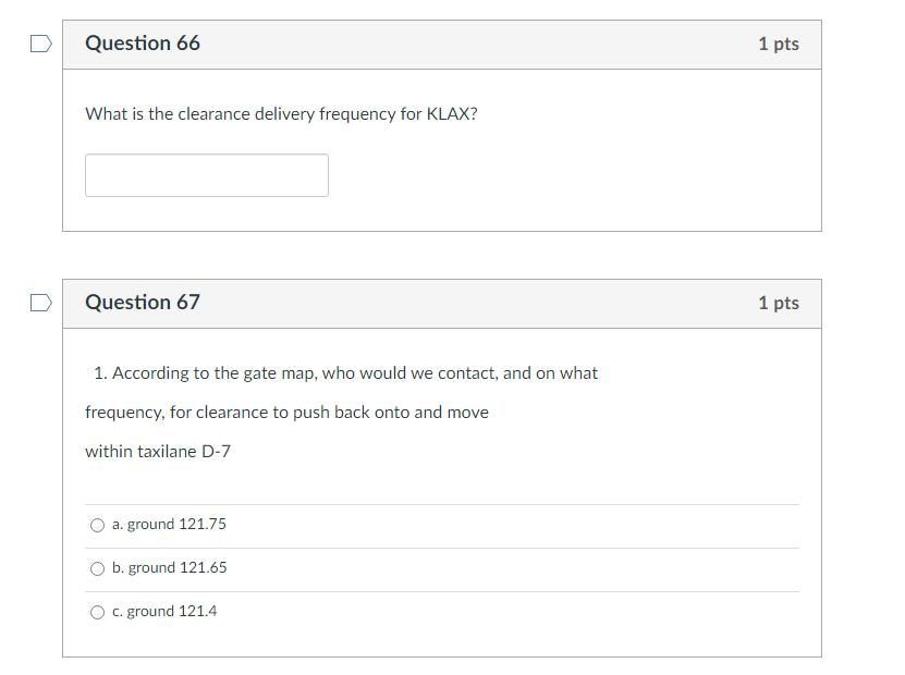
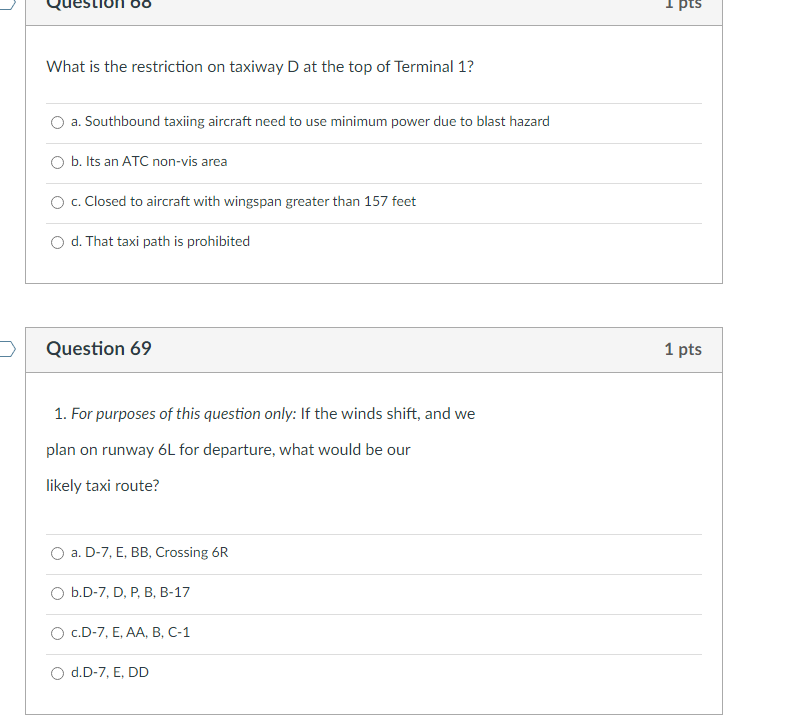
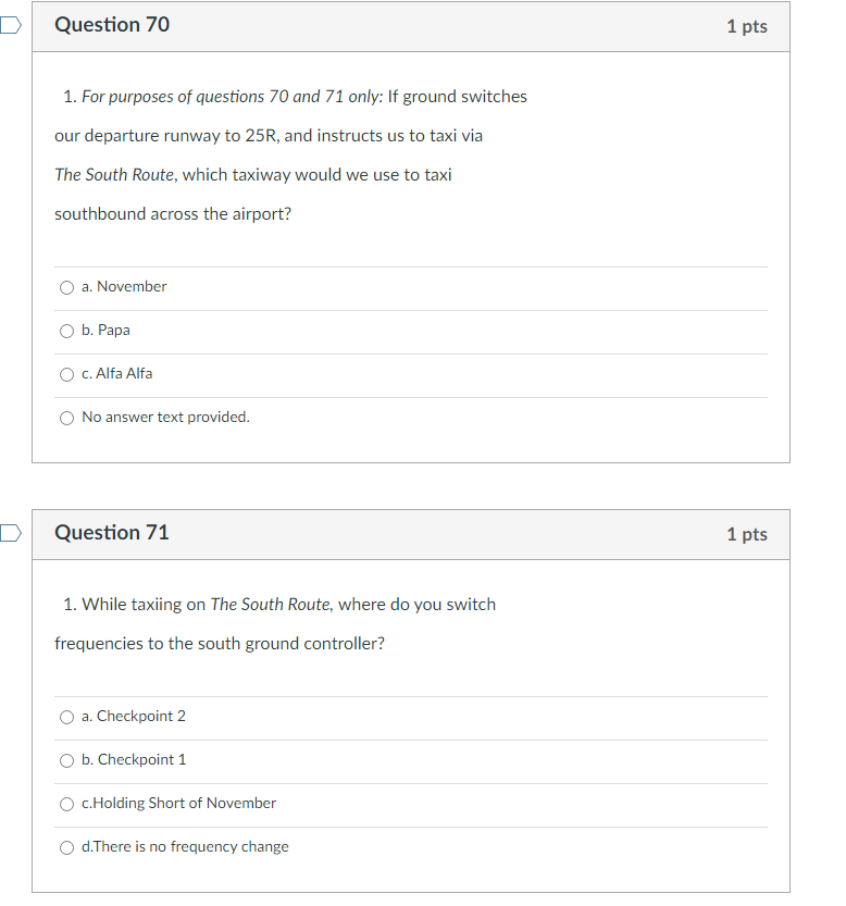
SOUTHWEST AIRLINES IFR DISPATCH RELEASE-1 JEPP PLAN# 9785 FLIGHT 1046 09/02/21 2213Z DEPART 2245Z ARRIVE 0150Z STE/ETE: 02+45/02+36 TAXI OUT: 00+14 KLAX/LAX: 1545L KDAL/DAL: 2050L TAXI IN: 00+06 1745C 2050C PROPOSED DEPARTURE TIME: 2252Z REMARKS : AC EQUIP - ELTS FANS CPDLC ENROUTE ADDITIONAL FUEL FOR ATC/AIRPORT ARRIVAL DEMAND FLT : AC : NOSE : TYPE : CAP : ATOG : LM : 1046 N8646B 8646 B737-800W 175 159.5 L DEPART : KLAX/LAX ( 128*) ARRIVE: KDAL/DAL ( 487") DIST : 1156 NM T/O ALTN: ALTN 1 : ALTN 2 : FMS RTE LAXDAL60: KLAX DOTSS2 CLEEE .PKE J74 SJN. .TXO. .TURKI JFRYE4 KDAL KLAX: N3356 .5 W11824.5 TOC: 370 WIND: 224/055 TEMP/DEV: M46/+11 FL CHANGE : 370 MEL/CDL : NO ITEMSFUEL TIME PLAN WEIGHT STRUC LIMIT ENROUTE BURN 0155 02+36 MO 093266 CONT/ HOLD 0021 00+25 PYLD 039000 DISP ADD 0017 00+20 ZFW 132300 MZFW 136500 ALTERNATE 0000 00+00 FOB 023800 MFW 046100 FAR RESERVE 0041 00+45 TOW 156100 MTOW 174200 MEL/ CDL 0000 BURN 015500 BALLAST 0000 LGW 140600 MLGW 144000 MINIMUM TAKEOFF 0234 04+06 MOTW 169600 EXTRA 0004 PLAN TAXI OUT 0004 00+14 MINIMUM PLANNED 0242 TANKER 0000 MAXIMUM PLANNED 0242 PLAN ARR FUEL 0083 01+35 ARR STN CONT FUEL IMPACT: 25 MIN AVG WIND P026 CRZ CI40 FUEL BURN ADJUSTMENT FOR 1000 LBS INCREASE IN TOW: 0099 LBS TAKEOFF : 24R WIND TEMP ONH RWY COND BLDS ENG AI FP WT LMT 000TOO 22 29. 88 6-DRY OFF OFF 5 174 .2 S LANDING: 13L WIND TEMP ONH RWY COND BLDS ENG/WNG AI ICE FP WT LMT OOOTOO 33 29.87 DISP-WET OFF OFF/OFF NO 40 159 .5 S OOOTOO 33 29. 87 5 -GOOD OFF OFF/OFF NO 40 159.5 SENROUTE : APU ENG A/ I ENROUTE (METHOD 1) NORM ON SEGMENT TERRAIN OVRWGT WT ALT NO LIMITING TERRAIN 174 . 2 NONE DSP : DESK: 80 PH: CAP : SIGNATURE : FITNESS FOR DUTY STATEMENT - - EACH CREWMEMBER AFFIRMATIVELY STATES HE OR SHE IS FIT FOR DUTY IN ACCORDANCE WITH 14 CFR PART 117. CAP : SIGNATURE :\f\f\fZORDA JFRYE4 256 790 370 510 039 107 0041 09.0 00+24 . . . ./. . . N3346 .9 W09829.4 463 462 M47 024/015 111 0121 00 .5 02+12 00+05 105 (TOP OF DESCENT COINCIDES WITH PREVIOUS CHECKPOINT) KDAL JFRYE4 - DSC 179 - - - - 08.4 00+00 N3250. 8 W09651.1 182 0000 00.6 02+36 00+24 178 ALTITUDE/ROUTE OPTIONS - - - ALTITUDE FUEL TIME FMS RTE NBR AC WT DOES NOT ALLOW HIGHER OPTION 350 0156 02+35 LAXDAL60 330 0159 02+35 LAXDAL60 ATC FLIGHT PLAN\f- ALTERNATE DATA - - - ELEV MSA DIST FL W/C TIME FUEL T/O ALTN DEST ALTN 1 - DEST ALTN 2ENROUTE WIND AND TEMPERATURE SUMMARY - - - - -- LAXDAL60 WPT FL250 FL290 FL310 FL330 FL370 FL410 KLAX DLREY 23025M2102 23035M3103 22042M3405 22052M3704 22060M4601 22055M5503 ENNEY 23025M2102 23035M3103 22042M3405 22052M3704 22060M4601 22055M5503 NAANC 23025M2102 23034M3103 22042M3505 22052M3704 22060M4601 22055M5503 HAYNK 23025M2102 23034M3103 22041M3505 22052M3704 22060M4601 22055M5503 PEVEE 23025M2102 23034M3103 22041M3405 22051M3704 22059M4600 22055M5503 HOLTZ 23026M2103 23036M3003 22042M3404 22051M3704 22058M4601 22054M5502 DOTSS 23026M2103 22037M3003 22044M3403 22050M3703 22056M4601 22054M5503 EYEDL 23027M2103 22040M2904 22046M3303 22050M3702 22055M4601 22054M5502 HOMER 23027M2003 22041M2904 22047M3303 22051M3602 22055M4601 22054M5502 CLEEE 23027M2004 22043M2804 22049M3202 22051M3601 22054M4603 22053M5603 PKE 23026M1904 22042M2804 22048M3203 22052M3602 22055M4602 23050M5603 NICKT 23025M1904 23042M2704 22048M3203 22051M3602 22053M4601 22049M5601 NABOB 23025M1804 23042M2604 23048M3102 23051M3601 22048M4602 22043M5601 PAYSO 22027M1703 23040M2603 23044M3101 23045M3601 23044M4601 22039M5602 CHEAR 22028M1703 23039M2602 23042M3101 23044M3601 23043M4601 22038M5602 SJN 22030M1702 23036M2601 23038M3001 23040M3601 23042M4601 22036M5602 TXO 23030M1700 24026M2601 24025M3101 23026M3601 24025M4601 23023M5603 TURKI 21015M1602 19018M2602 22014M3104 26011M3603 30010M4701 26009M5603 GANJA 23010M1603 17016M2603 14011M3105 06009M3605 36009M4701 35009M5701 DEDWT 04008M1703 12015M2602 12012M3103 07010M3604 01011M4702 00010M5701 ZORDA 11009M1701 11014M2601 10015M3102 07015M3604 02015M4702 01014M5701 GREGS 11014M1802 10020M2602 09024M3104 06021M3604 04020M4702 03018M5701 MNKEE 11019M1802 10029M2602 09027M3105 06026M3604 04024M4701 03021M5701 JFRYE 11020M1802 10027M2602 09031M3104 07028M3605 04025M4701 03022M5702 KDAL 10021M1802 10030M2603 09034M3104 07032M3606 0502 8M4702 04024M5701\fQuestion 45 1 pts Does this flight plan comply with Method 1 or Method 2 terrain clearance? iy a. Method 1 () b. Method 2 Question 46 Does the enroute terrain limit our takeoff weight at all? 7y a Yes ) b. No How far will we have travelled at top of climb (TOC)? number only Question 48 1 pts How long will it take us to reach TOC? numbers only Question 49 1 pts What is the identifier and frequency of the first VOR on our route? O a. PKE 117.9 O b. PKE 3406.1 O c. SJN 112.3 O d. SJN 3425.4 Question 50 1 pts What is our planned ground speed after crossing NABOB? numbers onlyQuestion 51 1 pts What is our planned Mach number? Question 52 1 pts Between which two waypoints is the longest leg of our flight? O a. TXO - TURKI O b. SJN - TXO O c. CHEAR - SJN O d. DEDWT - ZORDA Question 53 1 pts 1. According to the Flight Plan what is the Minimum Safe Altitude (MSA) over the SJN VOR? O a. 18000 O b. 21000 O c. 13500 O d. 12500How much fuel should be onboard crossing GANJA numbers only Question 55 1 pts If the turbulence at our cruising altitude is bad, could we request a higher altitude enroute? O a. yes, no problem. The B737 can go to FL410 O b. no, aircraft is weight limited Question 56 1 pts What is the takeoff time listed on the ICAO flight plan block? HHmm O 2252 O No answer text provided.D Question 57 1 pts How long after takeoff should we enter Fort Worth Center's airspace? HHMM 0146 O No answer text provided. D Question 58 1 pts Are we expecting any GPS outages? O a. No O b. Yes D Question 59 1 pts If Fort Worth Center descended us for traffic after TXO to FL 330, what would the winds be at TURKI? only the wind numbers not the temp.Question 60 1 pts Would this be more or less of a tailwind component from FL 3707 "y a.less "y b. more (y c. the same d. not enough information to determine Question 61 1 pts Your weather briefing package shows an area of Light to Moderate Turbulence from SJN to TXO from FL 240 to FL 450. Being the conscientious Captain you are, you want the Flight Attendants to be seated through this area. How long after takeoff should you tell them you will be having them take their jump seats? hh+mm Question 62 How long will they be seated ({time from SJN to TXO?) hh+mm D Question 63 1 pts The ride starts getting worse prior to SJN and you want to contact the dispatcher to discuss ride reports. What frequency would you call ARINC on? O a. 129.45 O b. 131.17 O c. 128.9 O d. 121.5 D Question 64 1 pts At what point is Top of Descent? D Question 65 1 pts What is the ATIS frequency for KLAX[ [ Question 66 What is the clearance delivery frequency for KLAX? Question 67 1. According to the gate map, who would we contact, and on what frequency, for clearance to push back onto and move within taxilane D-7 > a.ground 121.75 () b. ground 121.65 () c.ground 121.4 What is the restriction on taxiway D at the top of Terminal 1? O a. Southbound taxiing aircraft need to use minimum power due to blast hazard O b. Its an ATC non-vis area O c. Closed to aircraft with wingspan greater than 157 feet O d. That taxi path is prohibited Question 69 1 pts 1. For purposes of this question only: If the winds shift, and we plan on runway 6L for departure, what would be our likely taxi route? O a. D-7, E, BB, Crossing 6R O b.D-7, D, P. B, B-17 O C.D-7, E, AA, B, C-1 O d.D-7, E, DDQuestion 70 1 pts 1. For purposes of questions 70 and 71 only: If ground switches our departure runway to 25R, and instructs us to taxi via The South Route, which taxiway would we use to taxi southbound across the airport? (v a. Nowvember iy b. Papa iy c. Alfa Alfa "y Mo answer text provided. Question 71 1 pts 1. While taxiing on The South Route, where do you switch frequencies to the south ground controller? v a. Checkpoint 2 (v b. Checkpoint 1 "y c.Holding Short of November "y d.There is no frequency change
Step by Step Solution
There are 3 Steps involved in it
Step: 1
Get Instant Access to Expert-Tailored Solutions
See step-by-step solutions with expert insights and AI powered tools for academic success
Step: 2
Step: 3
Ace Your Homework with AI
Get the answers you need in no time with our AI-driven, step-by-step assistance