Question
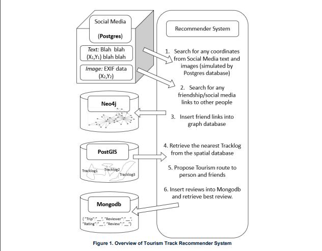
Tourism Track Recommender System Refer to Figure 1 for a high-level overview of the system to be developed. The company for whom you are developing
Tourism Track Recommender System Refer to Figure 1 for a high-level overview of the system to be developed. The company for whom you are developing this system wants people to visit local walks that are considered to have touristic appeal. For instance in Melbourne there are several tourism guide books and websites that detail walks that interested tourists can use to explore sites of local interest. In order to find potentially interested people, the company trawls various sources of social media (e.g. Facebook, Twitter, Instagram etc) for geocoded data - which could include a mention of a certain place, or coordinates tagging postings or hidden within image EXIF data. The geographic coordinates are then used to search through a database of tracklogs for local touristic walks. The nearest walk is retrieved and recommended to that person. Additionally, during the social media trawl, friendship links are gathered, and these are used to recommend the same retrieved walk to the persons' friends. The links are inserted into a separate database for later use. Additionally, anyone who wants to submit a review of their walking experience can do so. This is inserted into a separate database. NOTE: The complete scenario for the assignment will be discussed in lectures and support provided in tutorials, including appropriate algorithms for calculating the nearest tracklog.

Technical Details
While the system as explained appears to be a single application, you do not need to develop a Graphical User Interface that incorporates all of these different elements. Instead you merely need to demonstrate these different parts. The case study is used to motivate these different types of technology. To simulate the social media data, you will use a Postgres database, which will include tables of people (at least 5), their connections to other people, and some coordinates related to them - which supposedly originated from their social media profile. You can use the same Postgres database for the next spatial part but you will need to extend the PostgreSQL relational database to a PostGIS spatial database. You can write SQL commands in pgAdmin4 to create spatial data in the extended database, and write spatial queries using SQL. The PostGIS database will need to have some tracklogs inserted (at least 5), each comprised of at least 10 points. You will need to be able to query this database as follows: given a specific point (set of x,y coordinates), you are to find all tracklogs (as polygons) within which this point is contained. You are also required to retrieve the nearest tracklog if the point does not lie within a specific tracklog. For the spatial database tasks you should use the Spatial Reference ID (SRID) of 4326 for your spatial data. The Neo4j database will contain nodes representing people and links representing the relationships between these people. You will need to be able to insert new nodes and links into the database. You will need to be able to retrieve friends of a specific named person. Insert at least 5 people. The MongoDB document database will contain a collection of reviews, comprised of JSON documents that have appropriate key:value attributes, for instance keys such as "Trip name/ID", "Reviewer name/ID", "Rating", "Review" etc. You will need to write the code to insert at least 5 reviews. Use MongoDBCompass GUI and associated software mongosh to create the document database, create a collection in that document database, create documents within that collection, write MongoDB commands to populate the collection. You will also need to write MQL to query the database to find the best review.
Social Media (Postgres) Text: Blah blah (X1,Y) blah blah Image: EXIF data (X2,Y2) Neo4j PostGIS Tracklog Tracklog2 Tracklog3 Mongodb {"Trip" "Reviewer" "Rating" "Review" Recommender System 1. Search for any coordinates from Social Media text and images (simulated by Postgres database) 2. Search for any friendship/social media links to other people 3. Insert friend links into graph database 4. Retrieve the nearest Tracklog from the spatial database 5. Propose Tourism route to person and friends 6. Insert reviews into Mongodb and retrieve best review. Figure 1. Overview of Tourism Track Recommender System
Step by Step Solution
3.28 Rating (151 Votes )
There are 3 Steps involved in it
Step: 1
It seems like you have provided a detailed description of a Tourism Track Recommender System that involves multiple technologies and databases includi...
Get Instant Access to Expert-Tailored Solutions
See step-by-step solutions with expert insights and AI powered tools for academic success
Step: 2

Step: 3

Ace Your Homework with AI
Get the answers you need in no time with our AI-driven, step-by-step assistance
Get Started


