

Answered step by step
Verified Expert Solution
Question
1 Approved Answer
Write your algorithm using C code and document it with comments. Determine the running time of your algorithm using O-notation, as a function of n.
Write your algorithm using C code and document it with comments. Determine the running time of your algorithm using O-notation, as a function of n.
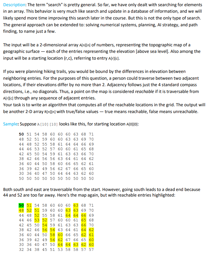
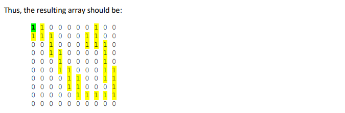
Description: The term "search" is pretty general. So far, we have only dealt with searching for elements in an array. This behavior is very much like search and update in a database of information, and we will likely spend more time improving this search later in the course. But this is not the only type of search The general approach can be extended to: solving numerical systems, planning, Al strategy, and path finding, to name just a few The input will be a 2-dimensional array A[n]In] of numbers, representing the topographic map of a geographic surface-each of the entries representing the elevation [above sea level]. Also among the input will be a starting location (r,c), referring to entry A[r][c] If you were planning hiking trails, you would be bound by the differences in elevation between neighboring entries. For the purposes of this question, a person could traverse between two adjacent locations, if their elevations differ by no more than 2. Adjacency follows just the 4 standard compass directions, i.e., no diagonals. Thus, a point on the map is considered reachable if it is traversable from A[rl[c] through any sequence of adjacent entries. Your task is to write an algorithm that computes all of the reachable locations in the grid. The output will be another 2-D array RIn]In] with true/false values-true means reachable, false means unreachable Sample: Suppose A [10] [10] looks like this, for starting location A [0]; 50 51 54 58 60 60 60 63 68 71 48 52 51 59 60 60 63 63 69 70 44 48 52 55 58 61 64 64 66 69 44 46 53 52 57 60 60 61 65 68 42 45 50 54 59 61 63 63 66 70 38 42 46 56 56 63 64 61 64 62 36 40 44 50 58 60 66 65 62 61 36 39 42 49 56 62 67 66 65 60 30 36 40 47 50 64 64 63 62 60 50 50 50 50 50 50 50 50 50 50 Both south and east are traversable from the start. However, going south leads to a dead end because 44 and 52 are too far away. Here's the map again, but with reachable entries highlighted 50 51 54 58 60 60 60 63 68 71 48 52 51 59 60 60 63 63 69 7 44 48 52 55 58 61 64 64 66 69 44 46 53 52 57 60 60 61 65 68 42 45 50 54 59 61 63 63 66 70 38 42 46 56 56 63 64 61 64 62 36 40 44 50 58 60 66 65 62 61 36 39 42 49 56 62 67 66 65 60 30 36 40 47 50 64 64 63 62 60 32 34 38 45 51 53 58 58 57 57
Step by Step Solution
There are 3 Steps involved in it
Step: 1

Get Instant Access to Expert-Tailored Solutions
See step-by-step solutions with expert insights and AI powered tools for academic success
Step: 2

Step: 3
Ace Your Homework with AI
Get the answers you need in no time with our AI-driven, step-by-step assistance
Get Started
Formal SQL Tuning For Oracle Databases Practical Efficiency Efficient Practice
Authors: Leonid Nossov ,Hanno Ernst ,Victor Chupis
1st Edition
3662570564, 978-3662570562